
The Panthesitic Order of Francis The Nazarite
Posted on November 30, 2024 by Royal Rosamond Press

Capturing Beauty
by
John Presco
ALL RIGHTS RESERVED
On this day, December 2, 2024, I John Gregory Presco, declare Cyber Monday the Day of The Order Pantheistic Francis. If you have ever been rejected by a religious body, or harassed by a group of people for your beliefs, or, if you family has utterly rejected for the sake of – their religious beliefs, then….
“Come unto me!”
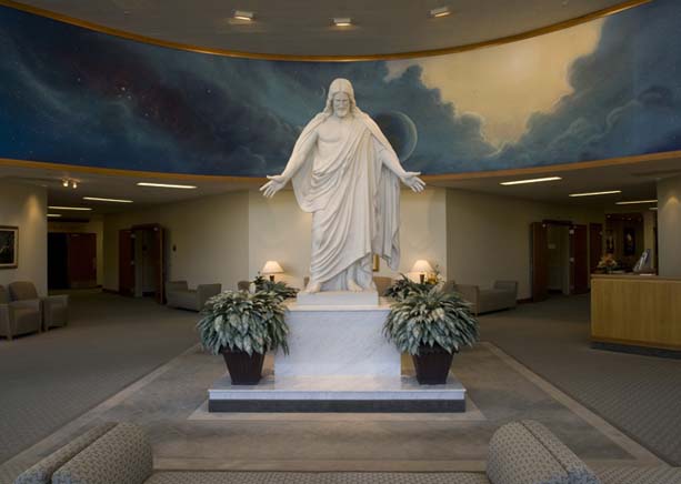
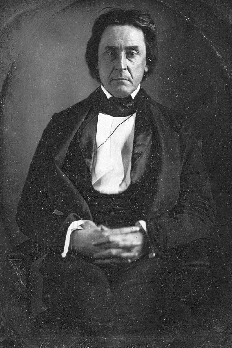
This morning I watched the Money Count on the News tallying up the billions Thanksgiving generated for the makers of goods. Cyber Monday, will rake in Billions. I have a claim to Thanksgiving via my ancestor, John Wilson, and the Cristus statue that overlooks my Stuttmeister ancestors. In seeing the A1 image of Jesus, I can no longer deny I look like the image in the Shroud. Several people have said so. Marilyn Reed said I stepped out of a El Greco. There will be a tithe so I can create an archive and prepare several theological books. No one will ever be alone – again!
My niece was thrown away! The police hunted down Drew’s cousin, and half-sister. They wanted nothing to do with Drew Taylor Rosamond Benton who made a living designing cyber avatars. This is……a sign! Cyber Monday IS devoid of any religious or spiritual observance. No one helped me pay the cost of cremating my niece. We spent Thanksgiving – alone! I got no gift from my kin. If you know your Torah and New Testiment, then you know I have been given a Great Inheritence!
My cup – overflows!
John Francis ‘The Pantheistic Nazarite’
EXTRA! After making a urgent appointment to see my doctor, I googled a person who founded a Aphrodite cult! Eureka! I believe I have found………..King Arthur! I can restore Camelot! I will author presentation and send it out. I got a trilogy here…..people! I have suffered greatly for Venus, and Rosamond, as you know!
I have been set free! I have set free…..The Captured!
The police report for Drew Benton says she stabbed herself twenty time with decorative knife, jumped off a balcony, pulled life support tubes out, and walked out of the hospital. Those who were close to her believe she was tortured.
New study says Shroud of Turin bloodstains are ‘consistent with Jesus Christ’s tortures’
Aug 30, 2024

The Shroud of Turin is pictured in a file photo during a preview for journalists at the Cathedral of St. John the Baptist in Turin, Italy. A study published in July revealed that a new analysis of the shroud, including the composition and a microscopic analysis of the blood, shows that the marks are consistent with the tortures endured by Christ as described in the Gospels. (CNS photo/Paul Haring)

A study published in July revealed that a new analysis of the Shroud of Turin, including the composition and a microscopic analysis of bloodstains, shows that the marks are consistent with the tortures endured by Christ as described in the Gospels.
The study, titled “New Insights on Blood Evidence from the Turin Shroud Consistent with Jesus Christ’s Tortures,” stated that the presence of creatinine particles with ferritin, which are often a by-product of muscle contractions, “confirms, at a microscopic level, the very heavy torture suffered by Jesus of the HST,” or Holy Shroud of Turin.
Furthermore, “numerous bloodstains scattered throughout the double body image of the HST show evidence that Jesus of the HST was tortured,” it stated.
“Bloodstained marks all over the body image which are consistent with pre-crucifixion flagellation, bloodstained marks on the head that are consistent with a ‘crown’ of thorns, blood marks on the hand and feet that are consistent with crucifixion and the bloodstain on the chest that evidences a post-mortem wound that corresponds with the post-mortem spear wound that Christ received as is described in the Bible,” the report said.
Posted on September 4, 2024 by Royal Rosamond Press
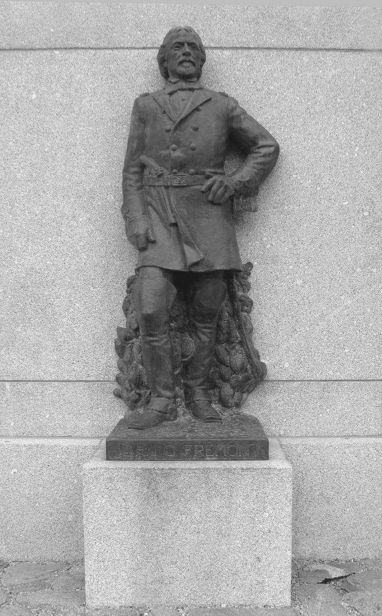
Bronze figure representing John C. Frémont by Mahonri M. Young, part of This Is the Place Monument, situated on the east bench of Salt Lake City, July 2012. Photograph by Alexander L. Baugh.
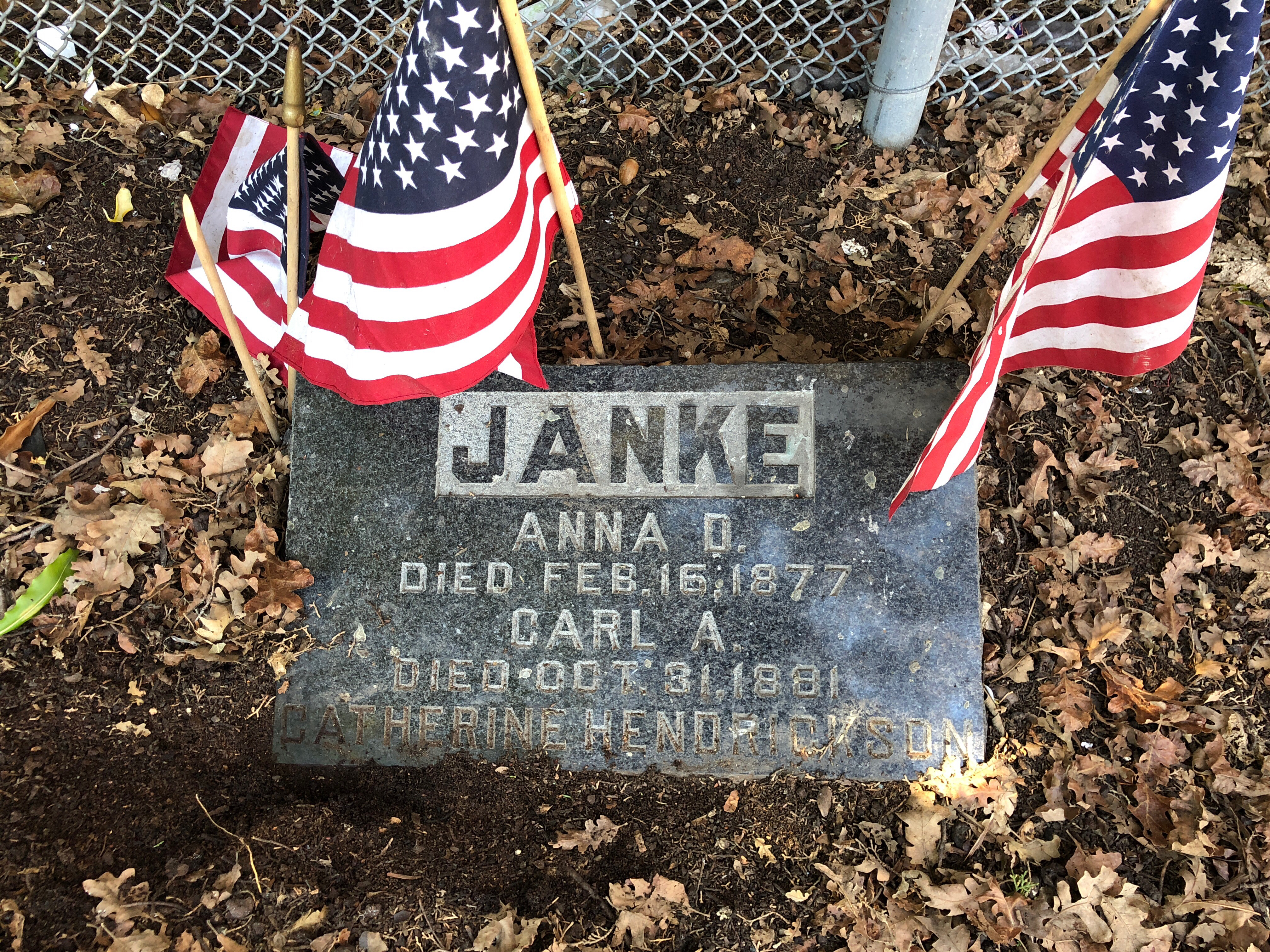
Denny Lawhern saw the Stuttmeister tomb in Berlin – and said nothing about it! He did not have the common courtesy to ask me who the family members are in the Stuttmeister-Janke crypt. If Lawhern found a family crypt like this in England, and, his dead folks are English, then he would hold Lawhern Crypt Night at the old folks home – every Sunday! If Denny learned his English ancestors were dug out of their graves outside London, because they were Oddfellows, then he would spend all the money he had on attorneys – in his rage to get revenge. Am I right? Can I get a witness?
After Cynthia McCarthy gave me the traditional Battlemont greeting, why didnt Denny invite me to hop on a plan and come to Belmont? He’ll pick me up at the airport. I could stay in his Big Winnebago in Twin Pines Park. I can wake to the sound of angry Frisbees being tossed at me – and my bloodline! Then, it’s off to Redwood City, to stand over…..this!!!
Last year I had four sisters over from the LDS church. When they saw the replica of Tharaldsen’s ‘Come Unto Me’ statue overlooking my Stuttmeister kin in Berlin, they got very excited because the LDS had undergone a major rebranding, and this was perhaps the only example of how the LDS Brand arrived in America. Two elder sisters came over and we were going to meet at the LDS genealogical room. They wanted to do the genealogy for all the people in this photograph, taken in Twin Pines Park. Lawhern and McCarthy THWARTED my genealogical study at the Belmont Historical Society. The LDS considers family “roots” to be central to their belief system. I am considering becoming a Mormon.
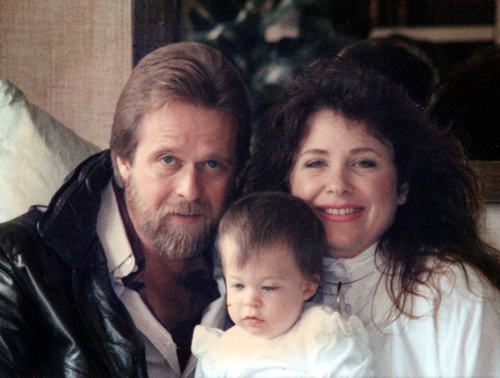
Ivanna has not responded to my questions – in three days! She did not return my call, today. I am short a thousand dollars, and Drew’s boyfriend is going to cover the rest. He gave me Drew’s Social Security. Nothing is to be done – until I sign the papers. If another relative has come forth, I got a verbal contract. I demand a DNA test of Drew be taken. That is Drew with her parents. She is an historic person, who may play a huge role in the LDS religion.
Did any seniors at the old folks home next to the park put Denny in their will because the abandoned ones felt Lawhern was the only one that cared when he had them get in touch with their “roots” and touch old stuff? Did he arrive early at those estate sales in order to rummage around and find historic artifacts? It took the head of the Belmont Historic Society five days to step in after I contacted the Mayor. How many people manned their computers – and rampaged though this blog? The last thing they wanted was for me to come to Belmont and rummage trough the BHS archives! They got two headstones there that were put in front of Ralston Hall in 1852. I sent a e-mail to the BHS and asked for the names. Did anybody do a search of their “roots” so they can inform their offspring – where they are? I’m going to send an e-mail to Stanford and inform them there are bodies all over the land – they want!
John Presco


On October 31, 2012, the California Department of Public Health mailed me a copy of my birth certificate. My mother and father were living on Berlin Way where William Stuttmesiter and his cousin, William Buyer built over forty new homes on this street, and on Maple Street just around the corner. My father had a framed marriage certificate of Frederick William Stuttmeister to a women named Charlotte. Vicki Presco did not have this certificate as I hoped. Vic’s mother’s middle name was Charlotte. Some citation on the web have Charlottenburg as the meaning of the name Stuttmeister. No. 1 Berlin Way was the address on this certificate. This street was founded by a King of Prussia who was into the Arts, thus one finds several famous Art Colleges here.
Hannah: Midrash and Aggadah | Jewish Women’s Archive (jwa.org)
(24) Bagdhad Cafe Lights – YouTube
God, College, Bankers, Liberty, Politicians, and John Witherspoon
Posted on February 28, 2012 by Royal Rosamond Press

John Witherspoon and his family were at one time the most educated in America. John was the President of Princeton. His daughter Ann married married Reverend Samuel Stanhope Smith who became the President of Princeton after John.

I believe the New Zion will be where the new LDS Temple is going to be built, a mile or more away from where I live. The Mormons built their cosmology on DNA and Family Trees. Deseret lies next to the Louisiana Purchase. I can now SEE all of what I saw in part. I have been called MAD by all who bonded with me. I kept a record of my Fantastic Quest! I can Baptize by the river.
I Am The Puritan Prophet
Posted on August 4, 2024 by Royal Rosamond Press

I can no longer escape my spiritual destiny. I try – and fail!
John ‘The Puritan Prophet’
Witherspoons In California
Posted on July 25, 2024 by Royal Rosamond Press


Dottie Wetherspoon and I had spiritual work to do when we came to California. we couldn’t find it. It was behind this……Great Gate!
The Witherspoon and Rosamond families are Patriots who lived in South Carolina whre Dottie and I went to the Meher Baba retreat. Kittie Davies recited her illustrious ancestors as we sat in the car.
“Why didn’t yu tell me who you are?”
Lady Ada Antionette Erasmus
Posted on August 14, 2021 by Royal Rosamond Press
I found this day The New Bohemian Puritan Church upon the union of Lady Erasmus, and Robert Wilson. The Evangelicals have launched a Catholic-like rebellion against a true Democracy that Pope Francis – must address! The Protestant Church of America is guilty of Popism, and must purge itself of Trumpism, the worst heresy ever to visit Christianity.
I have paid for the book on the descendants of John Wilson, my alleged great grandfather. John was the leader of the Massachusetts Bay Colony. I believe the Neo-Confederate Evangelical Traitors have put together a family tree that they want to rule America in the name of Jesus – with. I claim the history of all writers and artists that have had the name BOHEMIAN placed next to their name. Because my newspaper Royal Rosamond Press was founded in Eugene after the Miller Brothers, it is the foremost Bohemian Newspaper in the history of America. My fathers people immigrated from Bohemia. Bohemians have a long history of opposing Papal-like rule, something the Pranksters and Deadheads do not have a clue how to fight. How about Jack Kerouac and Ken Kesey? Did they author a great Bohemian Declaration before they died? How about Jack London who descends from Puritans?
John ‘The Puritan Prophet
Wilson and Webb
Posted on March 5, 2019 by Royal Rosamond Press

My kindred, William Wilson, and his brother-in-law, Erasmus Webb may have known William Shakespeare – intimately! Anne (Webb) Wilson lived at Windsor Castle. Her brother, Erasmus, was the Archdeacon of Buckingham Palace. Are we looking at the authors of Shakespeare’s plays? Why has this family lineage been buried, and all but forgotten? These are extremely educated men, whose wives would be at court. They would know all the intrigues, and, hear confessions. They would know the merry wives of Windsor. People would bring them all the gossip that is the bane of the church, aimed at bringing other down as they vie for royal favors.
This bloodline flows from Bohemia and has seeded several major religions. This is the ‘Hidden Seed’. The Webb family came to America. In the chart below we see that Sir Alexander Webb married Mary Wilson, the daughter of Thomas Wilson MP, the grandfather (or Great Uncle?) of Reverend John Wilson of the Massachusetts Bay Colony, that the Webb family played a large role in. Shakespeare’s line, died out, and thus, this is his American Seed.
Statesman, Thomas Wilson MP, was a stellar scholar and author who could have prepared the way for the writing of Shakespeare. Why not put Alexander Webb is the race? Surely the Webb-Wilson family saw themselves as the family-power behind the Church and Throne, and in need of new forum.
“Wilson belongs to the second rank of Elizabethan statesmen. An able linguist, he had numerous acquaintances among Spanish and Flemish officials in the Netherlands, and, in a wider context, his range of friends included Leicester, Burghley, Hatton, Davison, Sir Francis Knollys, Paulet, Walsingham, William of Orange, Jewel, Parker, Parkhurst, Gresham, Ludovico Guiccardini and Arias Montano.”
http://webb.skinnerwebb.com/gpage1.html
John Presco
Copyright 2019
Council of Fifty and The Kingdom of God
Posted on June 25, 2022 by Royal Rosamond Press
State of Deseret
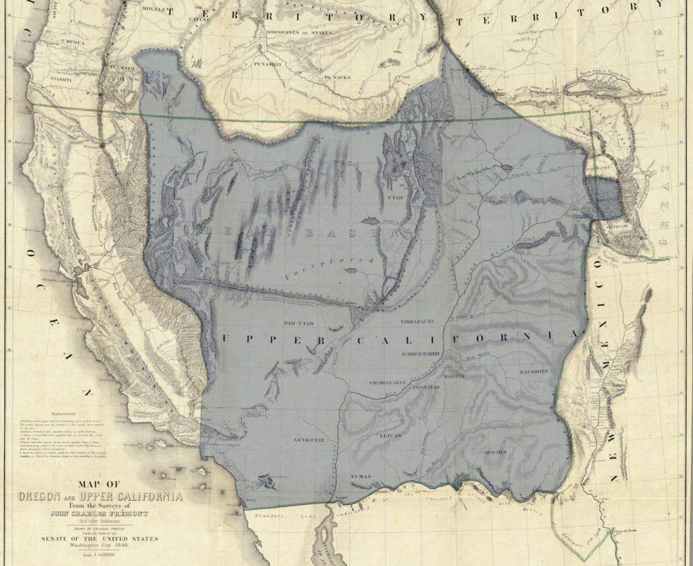
Based on “Map Of Oregon And Upper California . . . Bay of San Francisco” by Charles Preuss. David Rumsey Historical Map Collection.
I have long suspected John the Baptist was Baptizing everyone for citizenship in the Coming Kingdom of God – including Gentiles! His church was called The Way. The ‘Mormon Trail’ is one of the first names. I believe I am the embodiment of John and Moses – ordained to create a Water Way from the Mississippi to the Kingdom of Deseret.
Texas is seeking to seceded from the Union because they see themselves as part of the coming kingdom of the evangelical Jesus, who thru Justice Thomas has GONE AFTER women who want an abortion, and Gay People who want to be married. God has ruled that these blasphemer are not The Chosen to do THE JOB! I believe all the Mormons are The Chosen Builders. They own real organization skills.
Since the Two Witnesses came to me via my painting called ‘The Hill’ God and His Angels have been downloading much information. THIS IS GODS JOB – that he wants done! God parted the Red Sea!
“Let my people go!”
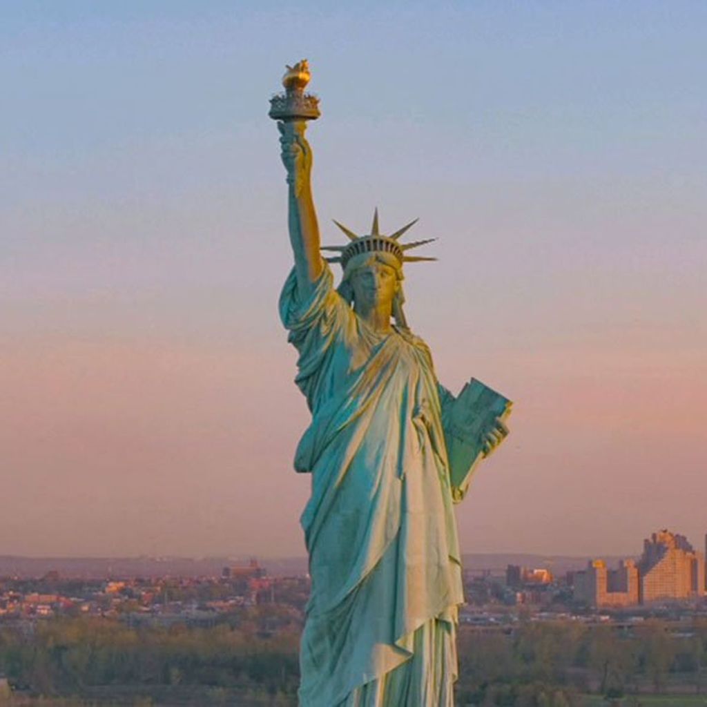
God wants to SAVE America! He hates the false crusade to hurt Gay People, here – and in Russia! I am His Messenger! He sent Two Witnesses to me. Our Lady Liberty is another Christus!
“Come unto me!”
John of The Way


With the light apparition in my painting ‘The Guardians of The Voice’ I have been led to look at the Two Witnesses in Revelations who may have been the men in white at Jesus’ tomb. Owning a near-death experience, I will go into a realm few can follow.
Seer John
The Resurrection of the TwoWitnesses
CNN talked about some of the perfect movies that have been made. They left out ‘Baghdad Cafe’. A vision came to me that reminded me of one of my favorite movies. Jack Palance’s
Role of the Council in the Utah Territory and state of Utah[edit]
See also: State of Deseret
Brigham Young (daguerreotype circa 1846)
After Smith’s death, the Council anointed Brigham Young its leader, and as the “king and president” of the Kingdom of God.[20] Under Young, the council helped organize the trek west from Nauvoo in 1846, and it largely governed the unorganized territory of Utah until Congress granted territorial status in 1850.
The Council assisted in the Mormon Exodus from Nauvoo, Illinois and the eventual migration to the Great Basin area of what is now Utah. Young relied upon the results of scouting missions by members of the Council in choosing the Great Basin as a destination for their exodus from Nauvoo, over several alternate possibilities including Texas, California, Oregon, and Vancouver Island.
The council was to act as a legislative body in the Kingdom of God,[21] and in Utah, the Council became a provisional legislative body in the government. This continued until September 1850 when Congress organized the Utah Territory upon petition by the church. After Utah became a territory, the American expectation for a separation between church and state sharply diminished the Council’s official role in government. The Council then suspended meetings in October 1851. The council met again only briefly in 1867 and 1868 and voted for the establishment of Zion’s Co-operative Mercantile Institution (ZCMI).
The Council resurfaced during the administration of John Taylor, to combat federal involvement in overseeing Utah elections.[22] The Council’s last recorded meeting was in 1884.
Deseret And John Fremont
Posted on June 24, 2022 by Royal Rosamond Press
I have found a Hidden Kingdom founded by Brigham Young. Here is my prophetic post made in 2015. I did not know about Deseret.
The State of Fremont | Rosamond Press
Here is my Facebook group that I began in 2015.
Here is a group who want to put parts of Oregon under the reign of Satan-Trump.
I see a New Migration along the Oregon Trail.
I told the Five Sisters that were in my home on June 23, 2022, that I kept seeing newsfeed about the Salt Lake drying up and creating a health crisis. I read an article about Lake Mead drying up, and the idea to divert water from the Mississippi. What I see is a New Exodus.
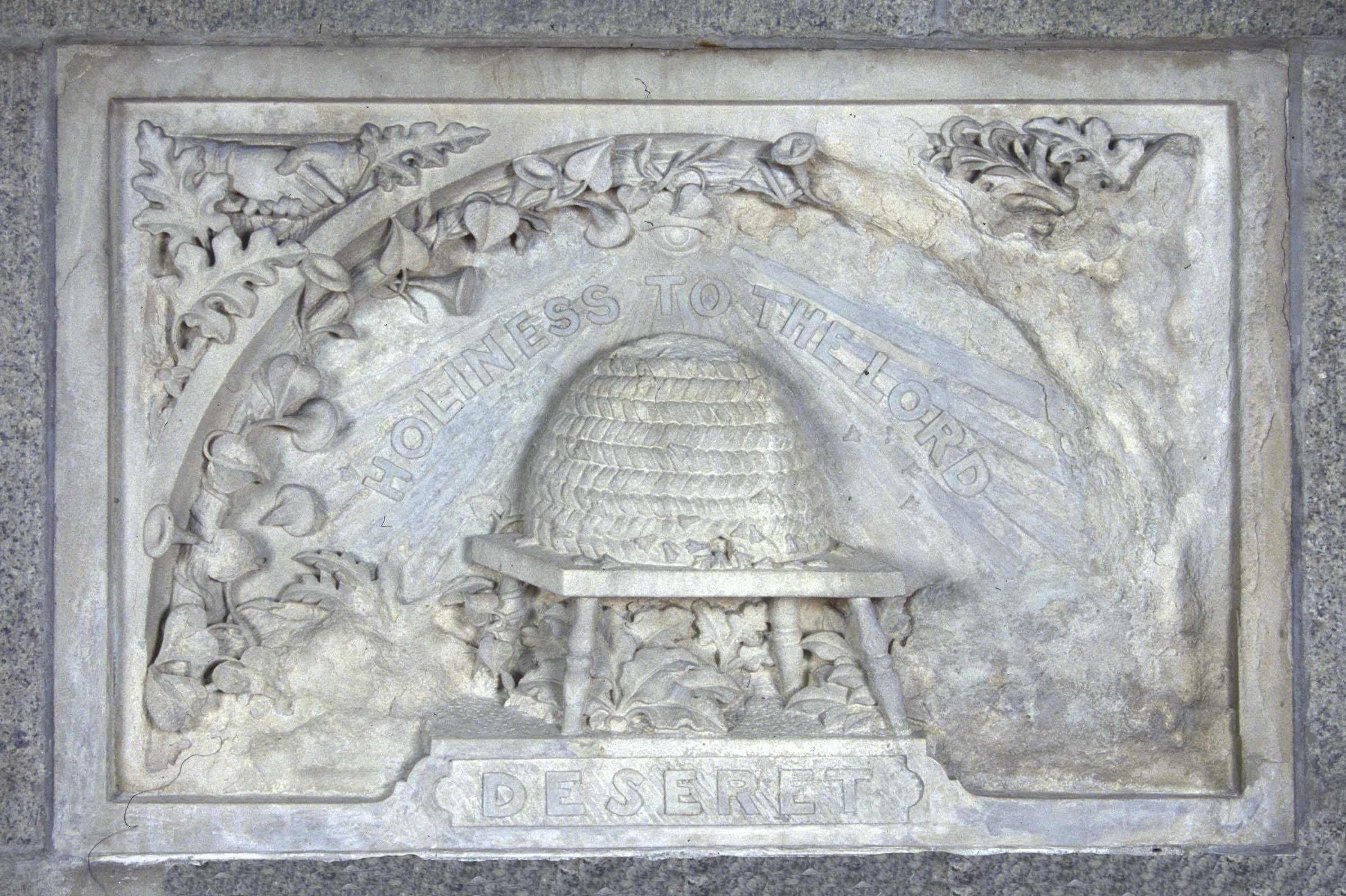
Above is the Deseret Stone showing a beehive with Masonic eye. My kin, Thomas H. Benton, saved Albert Pike’s Library.
John Presco
“When the Union Army attacked Little Rock, the commanding general, Thomas H. Benton, Grand Master of Masons in Iowa, posted a guard to protect the home of Pike and his Masonic library.”
Bill introduced in Utah Legislature to save the Great Salt Lake (ksltv.com)
Mormonism and Freemasonry – Wikipedia
The State of Deseret (/ˌdɛzəˈrɛt/ (listen))[1] was a provisional state of the United States, proposed in 1849 by settlers from The Church of Jesus Christ of Latter-day Saints (LDS Church) in Salt Lake City. The provisional state existed for slightly over two years and was never recognized by the United States government. The name derives from the word for “honeybee” in the Book of Mormon.[2]
History[edit]
Formation of the proposal[edit]
When members of the LDS Church (the Mormon pioneers) settled in the Salt Lake Valley near the Great Salt Lake in 1847 (then part of Mexico), they wished to set up a government that would be recognized by the United States.
Initially, church president Brigham Young intended to apply for status as a territory, and sent John Milton Bernhisel to Washington, D.C., with the petition for territorial status. Realizing that California and New Mexico were applying for admission as states, Young changed his mind and decided to petition for statehood.[citation needed]
In March 1849, realizing that they did not have time to follow the usual steps towards statehood, Young and a group of church elders quickly drafted a state constitution based on that of Iowa, where the Mormons had temporarily settled, and sent the legislative records and constitution back to that state for printing, since no printing press existed in the Great Basin at the time. They then sent a second messenger with a copy of the state’s formal records and constitution to meet up with Bernhisel in Washington, D.C., and to petition for statehood rather than territorial status.[citation needed]
Territory of Deseret[edit]
The Deseret Stone used in the construction of the Washington Monument. The stone was donated by the territory in 1853 to represent the provisional state.
The provisional state encompassed most of the territory that had been acquired from Mexico the previous year as the Mexican Cession.
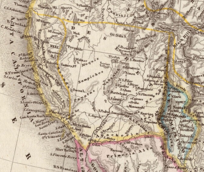
The Territory of Deseret would have comprised roughly all the lands between the Sierra Nevada and the Rockies, and between the border with Mexico northward to include parts of the Oregon Territory, as well as the coast of California south of the Santa Monica Mountains (including the existing settlements of Los Angeles and San Diego). This included the entire watershed of the Colorado River (excluding the lands south of the border with Mexico), as well as the entire area of the Great Basin.
The proposal encompassed nearly all of present-day Utah and Nevada, large portions of California and Arizona, and parts of Colorado, New Mexico, Wyoming, Idaho, and Oregon.
The relationship between Mormonism and Freemasonry began early in the life of Joseph Smith, founder of the Latter Day Saint movement. Smith’s older brother, Hyrum, and possibly his father were Freemasons while the family lived near Palmyra, New York.[1] In the late 1820s, the western New York region was swept with anti-Masonic fervor.
Nevertheless, by the 1840s, Smith and several prominent Latter Day Saints had become Freemasons and founded a Masonic Lodge in Nauvoo, Illinois on March 15, 1842. Soon after joining Freemasonry, Smith introduced the temple endowment ceremony including a number of symbolic elements that were very similar to those in Freemasonry. Smith remained a Freemason until his death; however, later leaders in the movement have distanced themselves from Freemasonry. In modern times, The Church of Jesus Christ of Latter-day Saints (LDS Church) has clarified in its Now You Know series that its members may become Freemasons.[2]
Radical Democracy Party (United States) – Wikipedia
The Church of Jesus Christ of the Latter-Day Saints (crwflags.com)
The state of Deseret flag still flies over Salt Lake City – The Salt Lake Tribune (sltrib.com)
Historical Flags of Our Ancestors – State of Utah – USA (loeser.us)
John (Fremont) Prepared Way For Brigham Young
Posted on June 24, 2022 by Royal Rosamond Press
Eureka!
John
This 1850 German map of the United States recognizes the State of Deseret’s claim to the Southern California coast. Note, however, that Deseret’s official boundaries included the pueblo of Los Angeles, which this map excludes. | Map of Vereinigte Staaten von Nord-America und Mexico by Carl Christian Franz Radefeld and Joseph Meyer. Courtesy of the Internet Archive.
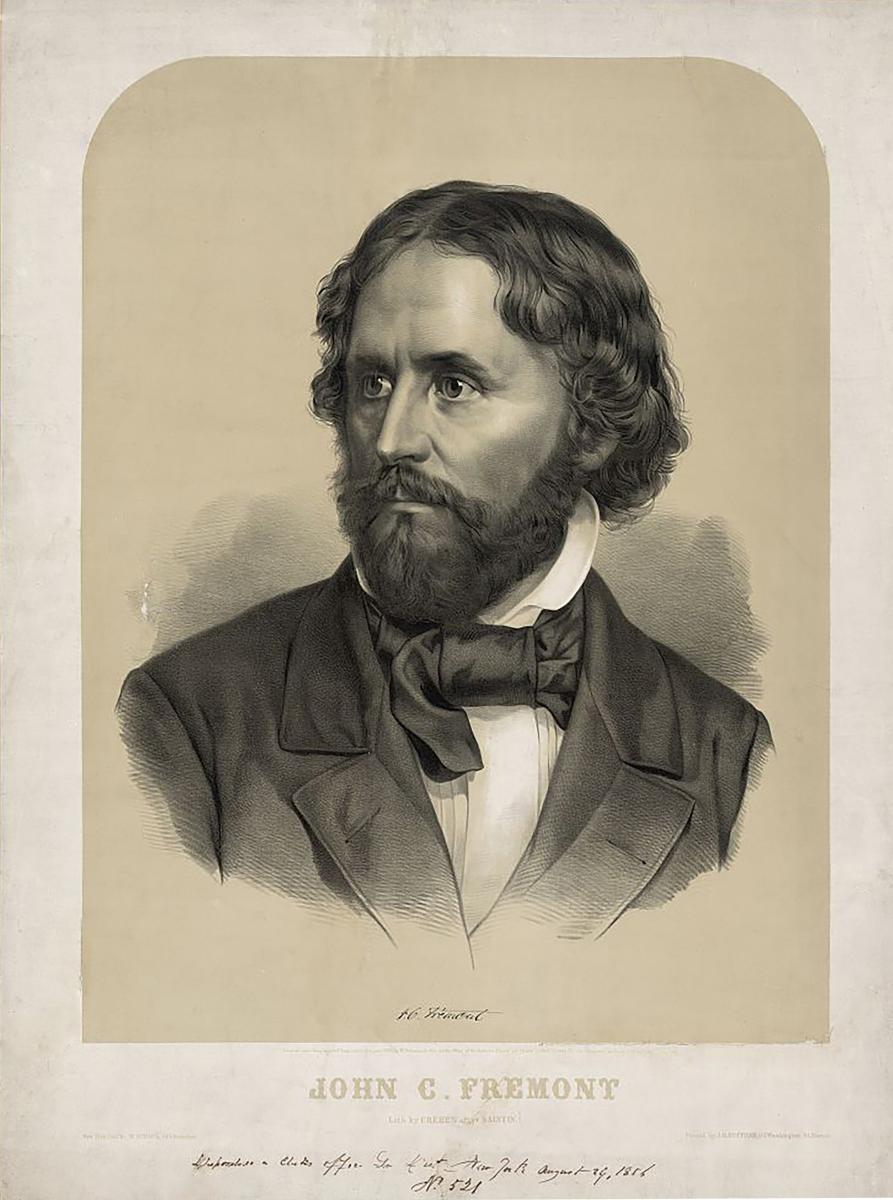
Lithograph by John Henry Bufford, Boston, Massachusetts, 1856. This image was made at the time Frémont was the Republican nominee for the U.S. presidency.
During the break in the Jan 6th. Hearing I google John Fremont and the Mormons and found this amazing article that says Brigham Young read the account of Fremont exploring Utah, and this inspired him to make his historic move.
“The people are so eager for it here that they have stole it out of the Library. The author is Mr. [Thomas Hart] Benton’s son-in-law. Judge D. [Douglas] borrowed it of Mr. B. [Benton]. I was not to tell any one in this city where I got it.”
EXTRA! June 23, 2020 5:45 P.M. I just found the Nation of Deseret that was proposed by the Mormons! Consider Fromond!
John Presco
The State of Deseret (/ˌdɛzəˈrɛt/ (listen))[1] was a provisional state of the United States, proposed in 1849 by settlers from The Church of Jesus Christ of Latter-day Saints (LDS Church) in Salt Lake City. The provisional state existed for slightly over two years and was never recognized by the United States government. The name derives from the word for “honeybee” in the Book of Mormon.[2]
The Benton DNA Test | Rosamond Press
Armstrong and Radio Free London | Rosamond Press
Frémont’s 1842 and 1843–44 Expeditions and the Mormons in Illinois
Frémont’s writings about his 1842 expedition to South Pass and the Wind River Range in Wyoming were read by Mormons in Illinois 1843, when portions of the explorer’s narrative from his first expedition were published in the Nauvoo Neighbor in October of that year.[19] John Taylor and Wilford Woodruff, coeditors of the Neighbor, did not indicate how they obtained the extracts from the expedition, or why they printed them, but newspaper editors often copied articles from other newspapers that circulated around the country. In early 1844 Joseph Smith obtained a printed copy of Frémont’s 1842 expedition courtesy of Illinois congressman Stephen A. Douglas from Washington, DC. In April, while Orson Hyde was in Washington, engaged in petitioning the government about matters concerning the Mormons and the possibilities of securing a place for the Church in the West, Hyde wrote to Church leaders in Illinois and informed them of the following:
Judge Douglass has given me a map of Oregon, and also a Report on an exploration of the Country lying between the Missouri River and the rocky Mountains on the line of line of <the> Kansas, and great Platte Rivers: by Lieut. J. C. Fremont of the Corps of topographical Engineers. On receiving it, I expressed a wish that Mr. Smith [Joseph Smith] could see it. Judge D. [Douglas] says it is a public document, and I will frank it to him. I accepted his offer, and the book will be forth coming to him. The people are so eager for it here that they have stole it out of the Library. The author is Mr. [Thomas Hart] Benton’s son-in-law. Judge D. [Douglas] borrowed it of Mr. B. [Benton]. I was not to tell any one in this city where I got it.
The book is a most valuable document to any one contemplating a journey to Oregon.[20]
It is important to note that the narrative and map of Frémont’s 1842 expedition to South Pass arrived in Nauvoo before the death of Joseph Smith. Mosiah Hancock said he heard Smith speak to the Nauvoo Legion just before his death, and pointing to Frémont’s map, he said: “I will show you the travels of this people. . . . Here you will make a place for the winter; and here you will travel west until you come to the valley of the Great Salt Lake.”[21] Even though Frémont did not come into Utah on his first expedition in 1842, it is significant that Joseph Smith and the Mormons were interested in Frémont’s western travels before they made any definitive plans for the western exodus.
Brigham Young and the Quorum of the Twelve Study Fremont’s Report
John C. Frémont’s 1843–44 Western Expedition and Its Influence on Mormon Settlement in Utah
Alexander L. Baugh
Alexander L. Baugh
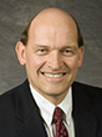
Alexander L. Baugh was a professor in the Department of Church History and Doctrine at BYU when this was written. He received his BS from Utah State University and his MA and PhD degrees from BYU. He specializes in researching and writing about the Missouri period of early Church history (1831–39). He is the author or editor of five books. In addition, he has published nearly fifty historical journal articles, essays, and book chapters. He is a member of the Mormon History Association, the Mormon Historic Sites Foundation, and the John Whitmer Historical Association, the last of which he served as president from 2006 to 2007. He is the editor of Mormon Historical Studies, codirector of research for the Religious Studies Center at BYU, and a volume editor for The Joseph Smith Papers. He is married to the former Susan Johnson, and they are the parents of five children and have six grandchildren. He and his family reside in Highland, Utah.
Lithograph by John Henry Bufford, Boston, Massachusetts, 1856. This image was made at the time Frémont was the Republican nominee for the U.S. presidency.
John Charles Frémont (1813–90) has been celebrated by historians as one of the most noted nineteenth-century explorers of the American West (figure 1). During a period of twelve years (1842–54), he personally led and directed five western expeditions to (1) South Pass and the Wind River Range in Wyoming in 1842; (2) the interior of the Rockies and the Pacific Coast in 1843–44; (3) California through Colorado, northern Utah, and central Nevada in 1845; (4) southern California through southern Colorado, New Mexico, and southern Arizona in 1848–49; and (5) northern California through southern Colorado, southern Utah, southern Nevada, and central California in 1853–54. Significantly, during his second expedition (1843–44), he traversed the interior of the Rockies (including northern, southern, central, and eastern Utah) and the Pacific coast. Following Fremont’s second expedition (1843–44), Frémont went to Washington, DC, where in collaboration with his wife, Jessie, he completed writing a report and producing detailed maps of both the 1842 and 1843–44 western expeditions. In 1845, Congress approved the printing of ten thousand copies of Frémont’s Report of the Exploring Expedition to the Rocky Mountains in the Year 1842, and to Oregon and North California in the Years 1843–44.[1]
Editors around the country peaked the public interest even further by including excerpts from the volume in their newspapers, which resulted in an even larger nationwide readership. Ultimately, the publication of the Report and the publicity that surrounded it, generated a growing national interest in the West, and fanned the flames of Oregon fever and U.S. expansionism among politicians, capitalists, adventurists, and unsettled Americans who believed that the remote regions of the west offered new possibilities of unlimited prosperity.
 John Charles Frémont, Matthew Brady Studio, ambrotype, circa 1856, National Portrait Gallery, Smithsonian Institution, Washington, DC.
Among those significantly impacted by Frémont’s early western explorations were the Mormons residing in western Illinois. The explorer’s favorable descriptions of the Bear River region, the Salt Lake Valley, and the Great Basin (the name Frémont gave to the territory) had a profound influence on Brigham Young and the Church’s leadership in their decision to select the Wasatch region of northern Utah as the main place of Mormon settlement.[2]
Frémont’s 1843–44 Expedition in the Utah Region
On March 10, 1843, Lieutenant Frémont received official notice from Colonel J. J. Abert, chief of the Army Topographical Engineers, to head a second expedition to the Far West. Abert’s instructions were for Frémont to map and survey the headwaters of the Arkansas River on the boundary between the Mexican and American borders in Colorado, then to do the same for the territory lying west of the Wind Rivers in Wyoming to the Columbia River on the Pacific. It was anticipated that the fulfillment of these objectives would provide the government a more accurate definition of the boundary between the United States and Mexico. Furthermore, when combined with Frémont’s 1842 survey of the area between the Kansas River and the Wind River Mountains, it was anticipated that the two reports would provide a detailed description (along with maps) of the entire route from the Missouri River to the Pacific.[3]
Frémont’s 1843–44 expedition party, consisting of thirty-nine men, left Westport Landing (Kansas City, Missouri) on May 29, 1843. The party traveled west through Kansas to Pueblo, Colorado, then north through the Medicine Bow Range in southern Wyoming, where they eventually reached the North Platte River, the Sweetwater River, and South Pass on the Oregon Trail. The expedition subsequently followed the Big Sandy River downstream, crossed the Green River, Blacks Fork, and Hams Fork, and then proceeded upstream on the Muddy River, where they reached the banks of the Bear River on August 21.[4] Upon the expedition’s arrival at the Bear River in western Wyoming, the lieutenant recognized that he was on the main tributary of the Great Salt Lake, which had been the subject of mystery and folklore among western travelers. Frémont recorded:
We are now entering a region which for us possessed a strange and extraordinary interest. We were upon the waters of the famous lake which forms a salient point among the remarkable geographic features of the country, and around which the vague and superstitious obscurity which we anticipated pleasure in dispelling, but which, in the meantime, left a crowded field for the exercise of our imagination. . . .
Hitherto this lake had been seen only by trappers who were wandering through the country in search of new beaver streams, caring very little for the geography; its islands had never been visited; and none were to be found who had entirely made a circuit of it shores; and no instrumental observation or geographical survey, of any description had ever been made anywhere in the neighboring region. It was generally supposed that it had no visible outlet; but among trappers, including those in my own camp, were many who believed that somewhere on its surface was a terrible whirlpool, through which its waters found their way to the ocean by some subterranean communication. All these things had made a frequent subject of discussion in our desultory conversations around the fires at night; and my own mind had become tolerably well filled with their indefinite pictures, and insensibly colored with their romantic descriptions, which, in the pleasure of excitement, I was well disposed to believe. And half expected to realize.[5]
Frémont considered the exploration of the Great Salt Lake so important to the success of the entire expedition that upon the party’s arrival at the big bend of the Bear River, for a period of twenty-six days (from August 25 to September 19), he left the main course of the Oregon Trail so that he might explore the lake.
The expedition continued to follow the course of the Bear River northward until they reached what is today Soda Springs, Idaho. Near this location, on August 25, instead of proceeding on towards Fort Hall (near Pocatello, Idaho), Frémont handpicked seven men and left the Oregon Trail to explore the inland sea. The rest of the company went on to Fort Hall to await their commander’s return.[6]
Following the Bear River southward, Frémont’s party camped just west of where Preston, Idaho, is today, then proceeded west until coming to the Malad River, which he called the Roseaux, or Reed River. Following the Malad southward, the expedition crossed the forty-second parallel into Utah and on September 1 camped three hundred yards above where the Malad flows into the Bear.[7] Two days later they reached the Bear River delta (what is today the Bear River Migratory Bird Refuge). The company then proceeded on a southward course east of the Great Salt Lake, somewhat parallel to the Wasatch Mountain range, before reaching the Weber River on September 5. Although they had been on the perimeter of the Great Salt Lake for several days, the men still had not seen the lake because they had traveled in the low-lying areas, where much of the view had been obscured by plant life. Leaving their camp on the Weber River on the morning of September 6, Frémont directed his men to a butte (now called Little Mountain), where for the first time the company experienced their first full view of the great inland sea.[8]
On September 9, using an eighteen-foot inflatable rubber boat loaded with provisions, fresh water, blankets, and scientific equipment and instruments, Lieutenant Frémont, Charles Preuss, Kit Carson, Baptiste Bernier, and Basil Lajunesse paddled out onto the lake and steered a course to a large island some five miles distant. Reaching the desolate island, they spent the better part of two days exploring and making scientific measurements and calculations. Frémont named the land mass “Disappointment Island,” because he had expected to find game and thick vegetation there but did not. The island has since been renamed Fremont Island in honor of the explorer (figure 1). [9]
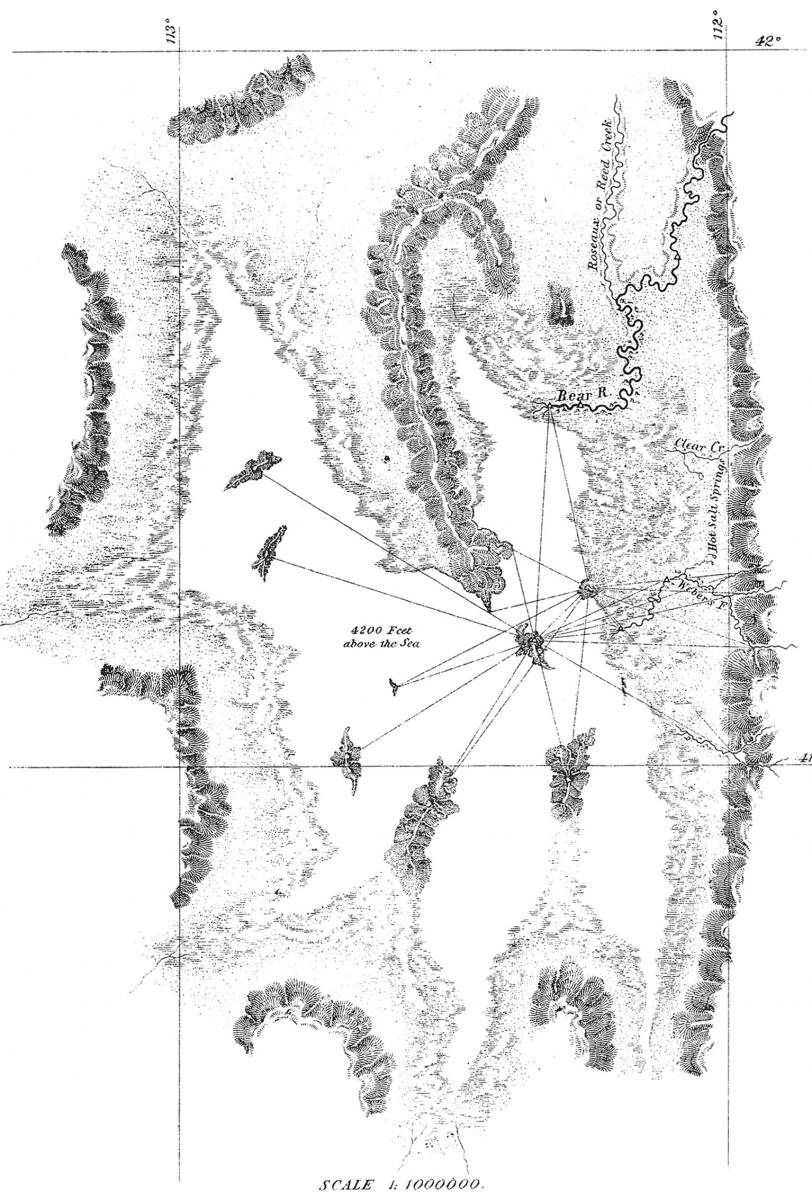 Figure 1. Frémont and Preuss, map of the Great Salt Lake.
On September 10, Frémont and his men left the island and paddled back to the mainland to begin the return trip to Fort Hall, where the main body of men in the expedition had been waiting. Frémont recorded that the party returned “by nearly the same route which we had traveled in coming to the lake.”[10] On September 15, four days after having departed from the lake’s shores, the expedition crossed the current northern Utah border into Idaho and arrived at Fort Hall on September 19.[11] All total, Frémont spent approximately two weeks (September 1–15) within the present confines of northern Utah (figure 2).
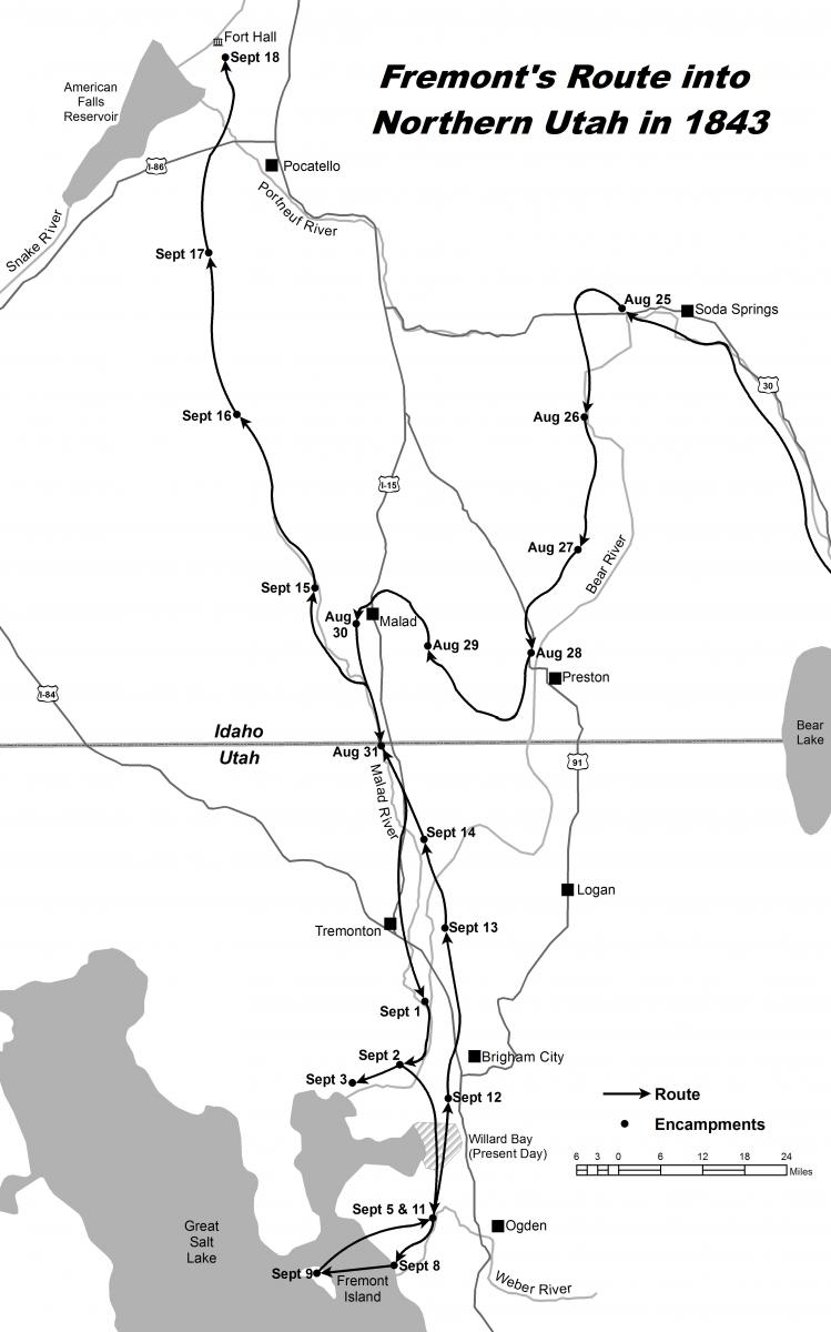 Figure 2. Map showing the route of Frémont’s expedition into northern Utah in 1843. Map by Weston P. Murch and Alexander L. Baugh.
The expedition departed Fort Hall on September 22 and followed the Snake River until reaching Fort Boise, situated on the junction of the Snake and Boise Rivers (the present border of Idaho and Oregon). About two weeks later, after proceeding on an overland journey through the Blue Mountains of Oregon, the government expedition arrived at Marcus Whitman’s mission near Walla Walla, Washington. After Frémont reached the Columbia River, his next destination was The Dalles, where his expedition arrived on November 5. From here, the lieutenant and a handful of men canoed down the Columbia to Fort Vancouver, where they arrived on November 8. With his arrival at Fort Vancouver, Frémont essentially fulfilled or completed the mission of the expedition, and from here he could have simply retraced his steps and returned to the east. However, having no intention to retrace his steps, he set out to conduct further explorations to the south.
At The Dalles, Frémont traveled due south along the eastern slope of the Cascade Mountains. Near Klamath Lake, the expedition headed south-southeast into northwestern Nevada. After making almost a complete circle along the eastern slope of the Sierra Nevada in central Nevada and California, Frémont finally chose to cross the formidable mountains slightly south of Lake Tahoe. It took the expedition from the middle of January to the first part of the month of March to travel through the Sierra Nevada to Sutter’s Fort. Leaving the fort during the latter part of March, Frémont journeyed through the Sacramento and San Joaquin Valleys. Upon striking the Mojave River, the explorer struck the Old Spanish Trail, then turned east en route to the Utah region once again.
On approximately May 10, 1844, while following the Virgin River upstream in the extreme southwest portion of present-day Utah, Frémont’s company entered the state’s confines a second time. Near what is today St. George, Frémont recorded that his men immediately began to display a more lively spirit because of the noticeable change of the country’s surroundings. The greener terrain of southern Utah was a welcome sight after their having traveled for several weeks through the dry territory of southeastern California and southern Nevada. “We seem to have entered a different climate,” the commander wrote. “The country is no longer so distressingly desolate.”[12]
By May 12, the company had advanced northward up the Santa Clara River into a pastoral area in low-lying mountains, which, in 1857, became the scene of the bloody massacre of emigrants passing through Utah on their way to California. Commonly known as Mountain Meadows, the area was the last resting spot for travelers on the Old Spanish Trail before proceeding across what is now the southern Nevada desert region. Although Frémont was traveling in the opposite direction, the meadows also served his expedition’s needs as a place for rest and recuperation. He wrote:
We found here an extensive meadow, rich in bunch grass, and fresh with numerous springs of clear water, all refreshing and delightful to look upon. It was, in fact, las Vegas de Santa Clara, which had been so long present to us as the terminating point of the desert, and where the annual caravan from California to New Mexico halted and recruited for some weeks. It was a very suitable place to recover from the fatigue and exhaustion of a month’s suffering in the hot and sterile desert. The meadow was about a mile wide, and some ten miles long, bordered by grassy hills and mountains.[13]
Leaving the meadows, Frémont descended into the broad Escalante Valley. Viewing the vast expanse to the west, the explorer realized that the chain of mountains to the east—the western rim of the southern Colorado Plateau (along with the Wasatch Range farther north)—formed the east rim of a large geographic basin that had no outlet to the sea. Frémont had earlier concluded that the Sierra Nevada range formed the basin’s western boundary. In his Report, Frémont appropriately designated this region the “Great Basin” (figure 3).[14]
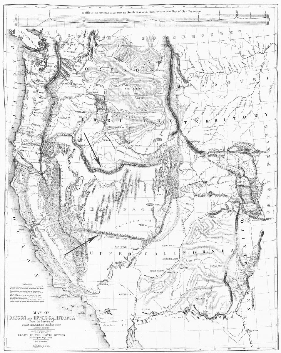 Figure 3. John C. Frémont and Charles Preuss, Map of Oregon and Upper California (1848), showing the Great Basin region identified by Frémont following his 1843–44 expedition. The arrows point to what Frémont incorrectly presumed were a northern and a southern mountain range that enclosed the Great Basin region.
With the arrival of the expedition at the Sevier River on May 23, Frémont’s party reached the last major river crossing before proceeding on to Utah Valley. Dominguez and Escalante had named the Sevier River and Sevier Lake on their expedition in 1776, and the explorer, being well aware of the names given to these two water sources by the Spanish Fathers, referred to them as such in his Report as well as on his 1845 map.[15]
On the morning of May 25, two days after crossing the Sevier, the expedition arrived in Utah Valley, where they camped for two days in two separate encampments (figure 4). During their time in the valley, the company encountered numerous Ute Indians near the lake, and one group provided the company with fresh fish, which Frémont called “salmon trout.”[16] The lieutenant was especially impressed with the area’s fertility and the numerous streams that flowed into the lake. “The lake is bordered by a plain, where the soil is generally good, and in greater part fertile; watered by a delta of prettily timbered streams,” he wrote. “This would be an excellent locality for stock farms; it is generally covered with good bunch grass, and would abundantly produce the ordinary grains.”[17]
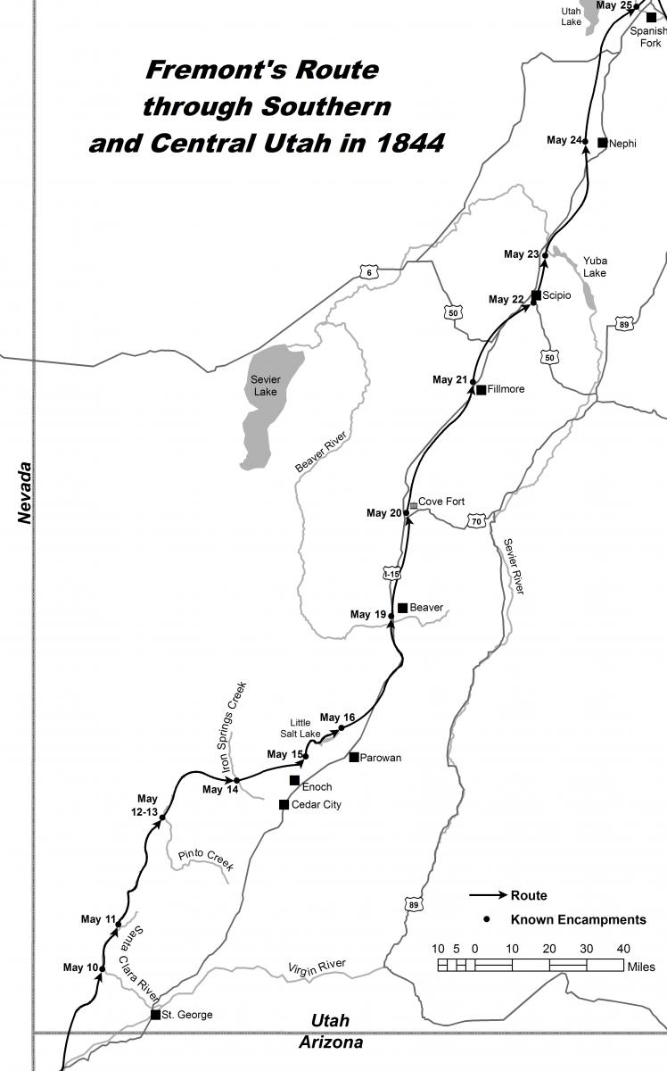 Figure 4. Map showing the route of Frémont’s expedition through southern and central Utah in 1844. Map by Weston P. Murch and Alexander L. Baugh.
On May 27, Frémont’s party exited Utah Valley through Spanish Fork Canyon. One week later they arrived at Fort Uinta (also called Fort Robidoux, after Antoine Robidoux) located on the Uinta River, where they stayed for two days. Leaving the fort on June 5, the company traveled some twenty-five miles in a northeast direction and camped on Ashley Creek. Two days later, on the afternoon of June 7, the expedition crossed the Green River and arrived at Brown’s hole near the present-day Utah-Colorado border.[18] In total, Frémont spent some forty-three days within the confines of Utah during the 1843–44 expedition—fifteen days exploring the northern portion of Utah in 1843 (September 1–15) and twenty-eight days traversing the southern, central, and eastern regions in 1844 (May 10–June 7; figure 5).
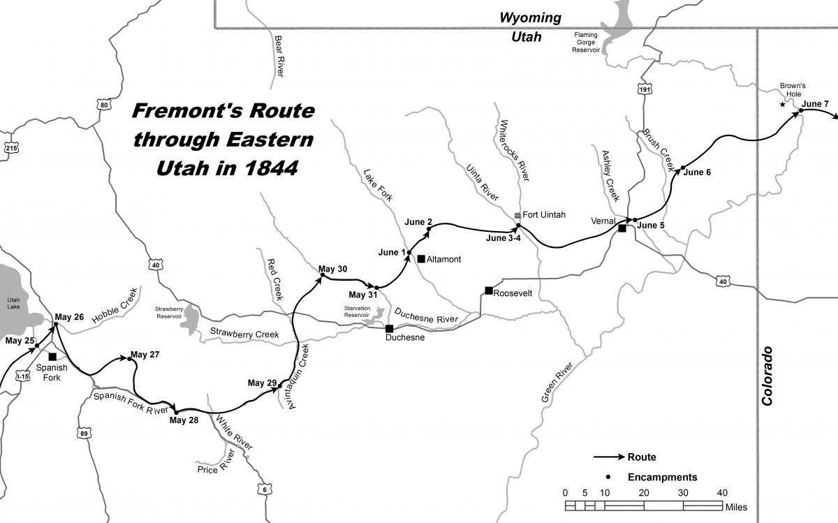 Figure 5. Map showing the route of Frémont’s expedition through eastern Utah in 1844. Map by Weston P. Murch and Alexander L. Baugh.
After leaving the Utah region, once again Frémont was not content to return east over familiar territory. From Brown’s Hole he traversed the central Colorado region before arriving at Pueblo on June 28 and Bent’s Fort on June 30. Leaving Bent’s Fort five days later, Frémont followed the Arkansas River eastward until reaching the northern bend of the river (near Great Bend, Kansas). There, the expedition journeyed overland to the Smoky Hill River, then followed the Smoky to the Kansas River until they reached the Santa Fe Trail. By August 6, fourteen months after the expedition officially began, the commander and his weary men arrived in St. Louis.
Frémont’s 1842 and 1843–44 Expeditions and the Mormons in Illinois
Frémont’s writings about his 1842 expedition to South Pass and the Wind River Range in Wyoming were read by Mormons in Illinois 1843, when portions of the explorer’s narrative from his first expedition were published in the Nauvoo Neighbor in October of that year.[19] John Taylor and Wilford Woodruff, coeditors of the Neighbor, did not indicate how they obtained the extracts from the expedition, or why they printed them, but newspaper editors often copied articles from other newspapers that circulated around the country. In early 1844 Joseph Smith obtained a printed copy of Frémont’s 1842 expedition courtesy of Illinois congressman Stephen A. Douglas from Washington, DC. In April, while Orson Hyde was in Washington, engaged in petitioning the government about matters concerning the Mormons and the possibilities of securing a place for the Church in the West, Hyde wrote to Church leaders in Illinois and informed them of the following:
Judge Douglass has given me a map of Oregon, and also a Report on an exploration of the Country lying between the Missouri River and the rocky Mountains on the line of line of <the> Kansas, and great Platte Rivers: by Lieut. J. C. Fremont of the Corps of topographical Engineers. On receiving it, I expressed a wish that Mr. Smith [Joseph Smith] could see it. Judge D. [Douglas] says it is a public document, and I will frank it to him. I accepted his offer, and the book will be forth coming to him. The people are so eager for it here that they have stole it out of the Library. The author is Mr. [Thomas Hart] Benton’s son-in-law. Judge D. [Douglas] borrowed it of Mr. B. [Benton]. I was not to tell any one in this city where I got it.
The book is a most valuable document to any one contemplating a journey to Oregon.[20]
It is important to note that the narrative and map of Frémont’s 1842 expedition to South Pass arrived in Nauvoo before the death of Joseph Smith. Mosiah Hancock said he heard Smith speak to the Nauvoo Legion just before his death, and pointing to Frémont’s map, he said: “I will show you the travels of this people. . . . Here you will make a place for the winter; and here you will travel west until you come to the valley of the Great Salt Lake.”[21] Even though Frémont did not come into Utah on his first expedition in 1842, it is significant that Joseph Smith and the Mormons were interested in Frémont’s western travels before they made any definitive plans for the western exodus.
Brigham Young and the Quorum of the Twelve Study Fremont’s Report
Upon completion of his 1843–44 expedition in August 1844 in St. Louis, Frémont returned to Washington, DC, to report to government leaders and to prepare for publication the account of his travels in the Rocky Mountains and the Pacific. By March 1, 1845, Frémont’s narrative of his second expedition, now ready for publication, led Congress to authorize the printing of ten thousand copies of a report detailing the 1842 and 1843–44 expeditions.[22]
Importantly, reports about Fremont’s second expedition to the West were printed in the Nauvoo Neighbor even before the completion of the published volume in Washington, DC. In late January 1845, the Neighbor published a brief sketch of Frémont’s 1843–44 expedition, including his reaching the Great Salt Lake and Utah Lake (spelled “Euta”).[23] In March, less than two months later, another article about the 1843–44 expedition appeared in the Neighbor with notably more space devoted to a description of the Utah region.[24] In September 1845, three issues of the Nauvoo Neighbor (September 10, 17, and 24) included information on both the 1842 and 1843–44 expeditions. However, by this time, the publishing of the ten thousand bound copies of Frémont’s Report had been completed and released for public sale. This is significant, since all three of the September 1845 issues of the Nauvoo Neighbor included actual excerpts from the Report, not merely summarized articles, clear evidence that by this time, the editors of the Neighbor were reprinting Frémont’s narrative from the published Report. For example, the September 17 issue of the Neighbor included actual extracts from Frémont’s Report under the dates of August 21, 23, and 25, 1843—the period of time when the explorer was following the course of the Bear River into the Utah region.[25] Perhaps more significantly, the September 24 issue of the Nauvoo Neighbor (the last issue which contained information about Frémont), included some four and a half columns filled of extracts from the Report under the dates of August 29–30, 1843, and September 6, 8–9, 1843, all dates in which Frémont was in the vicinity of Utah and the Great Salt Lake.[26] The closing paragraphs in the September 17 issue of the Neighbor perhaps reveal the extent to which the Mormons were interested in the Great Basin region by that time:
The Great Salt Lake, one of the wonders of nature, and perhaps without rival in the world, (being a saturated solution of salt, of a hundred miles in diameter,) is for the first time revealed to our view, by one who has surveyed its shores and navigated its waters.—The Bear River Valley, with its rich bottoms, fine grass, walled up mountains, hot springs, mineral springs, soda fountains, volcanic rock, volcanic crater, and saline effervescences, and four thousand five hundred feet above the sea, is for the first time described. . . .
Of the Geographical discoveries and descriptions, the most striking is that of the Great Basin or vast interior plane [sic] which lies between the Sierra Nevada and Rocky Mountains east and west, and between the Blue mountains and the Wahsatch [sic] on the South, and embracing and area of five or six hundred miles in diameter. The elevation of the Sierra Nevada being more lofty than the Rocky Mountains accounts for the formation of the Great Basin, as Lieutenant Frémont called it, and of which he is the first to announce its existence to the world. A basin which may hold such a kingdom as France, and which has for its rim a circle of mountains, whose summits penetrate the regions of eternal snow, is certainly a new and grand object to be revealed.[27]
By late August Mormon leaders had proposed that the main place of Mormon settlement would possibly be in the vicinity of Utah Lake in present-day Utah County.[28] However, those plans were quickly modified. On September 9, a general council resolved to send “a company of 1500 men be selected to go to the Great Salt Lake Valley.”[29]
Brigham Young and other Church leaders were intensely interested in Frémont’s Report and read from it frequently. For example, on December 20, 1845, members of the Quorum of the Twelve Apostles assembled in the attic room of the Nauvoo Temple, where they listened to Franklin D. Richards read from Frémont’s published narrative.[30] Heber C. Kimball wrote a few more details concerning the reading: “Pres. Young having slept in the Temple last night was early at his post, and dictating in relation to the business of the day. And arranging the workmen in order, . . . after which he listened to a reading from Capt. Fremont’s journal by Franklin D. Richards in the east room. . . . Amasa Lyman came in during the reading, also Heber C. Kimball, at a quarter to 10. The reading was finished at 10 o’clock.”[31] A week and a half later, on December 29, 1845, William Clayton reported that Young “spent near an hour reading Capt. Fremont’s Narrative, after which he retired for the night.”[32]
It is interesting to note that Brigham Young was misled in one particular way by Frémont’s reporting. After reading the Report, the Mormon leader was of the opinion that the Great Salt Lake and Utah Lake were in fact one lake. When Frémont was in the vicinity of Utah Lake for two days during the latter part of the month of May 1844, he explored only the southern portion of Utah Valley before heading east through Spanish Fork Canyon. Since he did not explore the region between Utah Lake and the Great Salt Lake, the explorer-scientist made the following incorrect conclusion about the relationship of the two bodies of water:
It [Utah Lake] is a lake of note in this country, under the dominion of the Utahs, who resort to it for fish. Its greatest breadth is about 15 miles, stretching far to the north, narrowing as it goes, and connecting with the Great Salt Lake. This is the report, and which I believe to be correct; but it [Utah Lake] is fresh water, while the other [the Great Salt Lake] is not only salt; but a saturated solution of salt; and here is a problem which requires to be solved. . . . The Utah [Lake] is the southern limb of the Great Salt Lake; and this we have seen that remarkable sheet of water both at its northern and southern extremity.[33]
Frémont’s conclusions about the two lakes were definitely inaccurate, and it is easy to see how Brigham Young was misled by the explorer’s reporting.
Some years after the Mormons settled in the Great Salt Lake Valley, Eli Perkins interviewed Brigham Young. During the course of the interview, Perkins recorded that when Brigham Young read Frémont’s Report, the Mormon leader came away with the idea that the Great Salt Lake was composed of both salt and fresh water. A portion of the Perkins-Young interview, which appeared in the New York Times, reads as follows:
“How came you to think of Utah?” I asked.
“Well, we had read an account of Gen. Fremont’s travels—how he found a large salt lake in the interior of our continent, in the middle of a fertile plain. We read the account of his rowing to an island in the centre of the lake in an India-rubber boat, and how the south end of the lake was fresh and the north salt.”
“But the south end of Salt Lake is not fresh, is it?” I asked.
“No; Fremont made a mistake. In going to the south of Salt Lake he struck Utah Lake, another lake, and thought it was a continuation of the same lake.”[34]
![]() Figure 6. John C. Frémont and Charles Preuss, Map of an Exploring Expedition to the Rocky Mountains in the Years 1842 and to Oregon & North California in the Years 1843–44 (1845). Upon completing his survey of the southern portion of the Utah Valley in 1844, Frémont incorrectly assumed that Utah Lake and the Great Salt Lake were one body of water connected by a narrow channel (see arrow).
Figure 6. John C. Frémont and Charles Preuss, Map of an Exploring Expedition to the Rocky Mountains in the Years 1842 and to Oregon & North California in the Years 1843–44 (1845). Upon completing his survey of the southern portion of the Utah Valley in 1844, Frémont incorrectly assumed that Utah Lake and the Great Salt Lake were one body of water connected by a narrow channel (see arrow).
When Frémont read the Perkins-Young interview in the Times, the explorer responded with his own explanation of the alleged discrepancy about the two lakes and insisted that he did not err in his reporting and that Brigham Young was in error.[35] However, from his description given in the Report, it is clear that in 1844 Frémont did not understand the true relationship of the two lakes. Two pieces of evidence support this conclusion. First, on the map of his 1842 and 1843–44 expeditions, Frémont and cartographer Charles Preuss joined Utah Lake and the Great Salt Lake with a rather large narrow channel, essentially making them one lake (figure 6). Second, in his expedition through Utah the following year (1845), Frémont spent some two weeks in the vicinity of both Utah Lake and the Great Salt Lake. On this occasion he investigated the northern shore of Utah Lake and clearly saw what is today the Jordan River flowing some twenty-five miles northward into the Great Salt Lake. It was at this time that he clearly understood the relationship between the two bodies of water. This is evident from Frémont’s 1848 map, on which he made the necessary correction and showed the two lakes being connected by the Jordan River (figure 7).
Excerpts of Fremont’s Report Published in the Millennial Star
By 1846, converts to The Church of Jesus Christ of Latter-day Saints living in the British Isles could also read about Fremont’s adventures in the American West and more specifically the Great Basin region. When Congress ordered that the Report be printed, no copyright was attached to the document, and publishers were free to reproduce the Report without restriction, resulting in numerous publishing companies reprinting the document under various titles. In 1846, for example, Wiley Putnam Publishers of London completed a printing of Frémont’s narrative. Using the Wiley Putnam edition, Orson Hyde, editor of the Millennial Star, a newspaper published in Liverpool, printed excerpts of Frémont’s 1843–44 expedition. On March 1, 1846, the first passages of Frémont’s Report appeared in the Millennial Star, and accounts continued to appear in the newspaper until October 15, 1846.[36] Perhaps Hyde hoped that by publishing Frémont’s favorable descriptions of the newly proposed Mormon place of settlement, British Mormons would be more inclined to gather to Zion.
![]() Figure 7. John C. Frémont and Charles Preuss, Map of Oregon and Upper California (1848). While en route to California in 1845, Frémont passed through the northern Utah region, bringing him once again in the vicinity of Utah Lake and the Great Salt Lake. On this occasion, he observed firsthand that the two lakes were actually not connected by a narrow channel but that Utah Lake had an outlet—the Jordan River (titled the “Utah” River by Frémont on his map)—which flowed north and emptied into the Great Salt Lake (see arrow).
Figure 7. John C. Frémont and Charles Preuss, Map of Oregon and Upper California (1848). While en route to California in 1845, Frémont passed through the northern Utah region, bringing him once again in the vicinity of Utah Lake and the Great Salt Lake. On this occasion, he observed firsthand that the two lakes were actually not connected by a narrow channel but that Utah Lake had an outlet—the Jordan River (titled the “Utah” River by Frémont on his map)—which flowed north and emptied into the Great Salt Lake (see arrow).
Mormon Leaders Acquire Frémont’s 1845 Map
Although the Mormons obtained a copy of Frémont’s narrative of the 1842 expedition by early 1844 and the explorer’s published Report of the 1842 and 1843–44 expeditions by September 1845, Church leaders apparently did not obtain Fremont’s map of the “combined” expeditions until March 27, 1847, just a few days prior to leaving Winter Quarters for the trek west. Brigham Young noted that on this date he received a copy of Fremont’s Map of an Exploring Expedition to the Rocky Mountains in the Years 1842 and to Oregon & North California in the Years 1843–44 (published 1845) from Missouri Senator David R. Atchison, and former legal counsel to the Mormons in Missouri.[37] Upon completion of the second expedition, Frémont and his cartographer, Charles Preuss, combined to produce a large lithographed map of both the 1842 and 1843–44 expeditions. Like the Report, the map was also completed in 1845, but it was published separately. This explains how the Saints could have obtained a copy of the Report in 1845, but not the large detailed map. There can be little doubt that the map given by Atchison to Mormon leaders at Winter Quarters was Frémont’s 1845 map. On April 4, 1847, eight days after receiving it, Young recorded: “T [Thomas] Bullock made a sketch of Capt. Fremont’s topographical map of [the] road to Oregon for the use of the Pioneers.”[38]
 Daguerreotype of David Rice Atchison by Mathew Brady; March 1849. Atchison served two terms as a U.S. senator from Missouri (1843–55). In an act of interest and kindness, in early 1847 Atchison sent a copy of John C. Frémont’s Map of an Exploring Expedition to the Rocky Mountains in the Years 1842 and to Oregon & North California in the Years 1843–44 to Mormon leaders at Winter Quarters to assist them in their journey west. Image courtesy of Beinecke Rare Book and Manuscript Library, Yale University, New Haven, CT.
It appears that the main contribution Mormon leaders obtained from Frémont’s Report was not necessarily to assist them in knowing the route which they were to travel to the valley of the Great Salt Lake, although the Report and maps certainly gave them assistance. Of greater importance and concern was learning about the agricultural and geographic characteristics of the region in order to assess whether the region would meet the needs of the vast number of people they envisioned would settle in the region. Assessments by Frémont, such as the following, must have played an important part in the decision by the Church’s leadership to settle in the vicinity of the Great Salt Lake:
Taking leave at this point of the water of the Bear River, and of the geographical basin which encloses the system of rivers and creeks which belong to the Great Salt Lake, and which so richly deserves a future and detailed and ample exploration, I can say of it, in general terms, that the bottoms of this river, (Bear) and some of the creeks which I saw, form a natural resting and recruiting station for travelers, now, and in all time to come. The bottoms are extensive; water excellent; timber sufficient; the soil good, and well adapted to the grains and grasses to such an elevated region.[39]
And another:
I can only say, in general and comparative terms, that, in that branch of agriculture which implies the cultivation of grains and staple crops, it would be inferior to the Atlantic States, though many parts are superior for wheat; while in the rearing of flocks and herd it would claim a high price. Its grazing capabilities are great; and even in the indigenous grass not there, and element of individual and national wealth may be found.[40]
In 1848, when he presented his Geographical Memoir Upon Upper California to the United States Senate, Frémont was no doubt pleased to report to the lawmakers that the Mormon people had settled in the Great Basin, an area he promoted as being rich in natural resources. And although he reported that “the general character of the Great Basin was that of a desert,” he also added, “but with great expectations, there being many parts of it very fit for the residence of a civilized people; and of these parts, the Mormons have lately established themselves in one of the largest and the best.”[41]
Conclusion
Frémont’s published narratives and maps from his first and second expeditions had a profound impact on the Mormons in Illinois. Mormon leaders were particularly interested in the information he provided about the geographical elements, and the agricultural and economic potential of the Bear River area, the Salt Lake Valley, and the Great Basin in general. The explorer’s assessment of this geographic region played a significant part in the decision by Mormon leaders in Illinois in their selection of northern Utah as the main place of Mormon settlement in the West.
Bronze figure representing John C. Frémont by Mahonri M. Young, part of This Is the Place Monument, situated on the east bench of Salt Lake City, July 2012. Photograph by Alexander L. Baugh.
High on the bench east of Salt Lake City is the This Is the Place Monument, erected and dedicated in 1947 as part of the centennial celebration commemorating the arrival of the Mormon pioneers in July 1847. Featured on the granite base and tower are a number of bronze-cast figures created by the renowned Latter-day Saint sculptor Mahonri M. Young (grandson of Brigham Young). Most notable are the large statues of Mormon leaders Brigham Young, Heber C. Kimball, and Wilford Woodruff, who stand atop the centerpiece while gazing to the west over the Salt Lake Valley. In addition, nearly twenty other figures are situated around the monument’s base, including one representing John C. Frémont. A plaque, placed in front, provides a fitting tribute highlighting the contributions of the explorer to the Utah region and his influence upon the Mormon populace:
John C. Fremont
1813–1890
Pathfinder, explorer, soldier, statesman. Led five significant exploring and scientific expeditions to the West, 1842–54, three of which traversed the Great Basin to California. Conducted the first scientific exploration of the Great Salt Lake in 1843 and was the first to traverse the treacherous Great Salt Lake Desert directly westward from [the] Great Salt Lake to the site of modern Elko, Nevada. His report and map published in 1845 were invaluable to the Mormon pioneers in their westward journey.
Notes
—
[1] An earlier version of this article appeared in the Utah Historical Quarterly 83, no. 4 (Fall 2015). The definitive study on John C. Frémont’s western expeditions is Donald Jackson and Mary Lee Spence, eds., The Expeditions of John Charles Frémont, 3 vols. (Urbana: University of Illinois Press, 1970–84). For a brief discussion of the maps that accompanied Frémont’s reports of the 1842 and 1843–44 expeditions, see Douglas Seefeldt, “Cartographic Representations of the American West on the Eve of the Mormon Exodus,” chapter 1 in this volume.
[2] See Alexander L. Baugh, “John C. Fremont’s Expeditions into Utah: An Historical Analysis of the Explorer’s Contributions and Significance to the Region” (master’s thesis, Brigham Young University, 1986). Previous studies about Frémont in the Utah region include Andrew Love Neff, “John C. Fremont,” Utah Educational Review 21, no. 8 (April 1928): 432–33, 458–61; 21, no. 9 (May 1928): 496–97, 538–41; David E. Miller, “John C. Fremont in Utah,” Historian 11 (1948): 14–28; and Mary Lee Spence, “The Fremonts and Utah,” Utah Historical Quarterly 44, no. 3 (Summer 1976): 286–302.
[3] J. J. Abert to John C. Fremont, March 10, 1843, in Jackson and Spence, The Expeditions of John Charles Fremont, 1:160–61.
[4] John Charles Frémont, Report of the Exploring Expedition to the Rocky Mountains in the Year 1842, and to Oregon and North California in the Years 1843–44 by Brevet Captain J. C. Frémont of the Topographical Engineers, Under the Order of Col. J. J. Abert, Chief of the Topographical Bureau (Washington, DC: Gales and Seaton, 1845), 132 (hereafter cited as Frémont, Report. The Report was initially published as a Senate document (28th Congress, 2nd session, Senate executive document 174, serial 461). No copyright was issued for the Report, and numerous publishers reprinted the document under various titles. A memorial marker has been erected near Evanston, Wyoming, commemorating the site where the expedition encamped on the Bear River.
[5] Frémont, Report, 132–33.
[6] Frémont, Report, 135–36.
[7] Frémont, Report, 140–47.
[8] Frémont, Report, 147–51.
[9] Frémont, Report, 153–58.
[10] Frémont, Report, 158.
[11] Theodore Talbot, one of the members of the expedition who waited at Fort Hall while the smaller expeditionary force explored the lake, recorded that Frémont’s company arrived at Fort Hall on September 18. See Charles Carey, ed., The Journals of Theodore Talbot, 1843 and 1849–52, with the Frémont Expedition of 1843 and with the First Military Company in the Oregon Territory, 1849–52 (Portland: Metropolitan Press, 1931), 50. Apparently Frémont arrived back at Fort Hall late in the day of September 18, but he did not meet with the men from his company who had remained behind at the fort until the next day. See Frémont, Report, 162.
[12] Frémont, Report, 270.
[13] Frémont, Report, 270.
[14] Frémont, Report, 272. The map Frémont and his cartographer, Charles Preuss, produced following the 1842 and 1843–44 expeditions shows relatively little information about the interior of the Great Basin, but it is obvious that Frémont clearly understood the relationship of the Wasatch and southern Colorado Plateau with that of the Sierra Nevada in forming the eastern and western boundaries of the Great Basin. However, in 1848, when the two men combined to produce yet another topographical map of the western U.S. region, they inaccurately placed two mountain ranges running east and west at both the northern and southern extremities of the basin. Frémont was obviously under the assumption that since the area had no outlet to the sea, and since the basin clearly had an eastern and western boundary, it must also have been bordered by a northern and a southern mountain range. In defining the Great Basin, Frémont also dispelled a myth that had persisted for decades—that a river flowed from the Rockies to the Pacific. This river, usually referred to as Buenaventura, began to appear on maps following the 1776 Dominguez-Escalante expedition. However, following Frémont’s 1843–44 expedition, the mythical river virtually disappeared from maps.
[15] Frémont, Report, 272.
[16] Frémont, Report, 273.
[17] Frémont, Report, 274.
[18] Frémont, Report, 277–79.
[19] See “South Pass to Oregon,” Nauvoo Neighbor 1, no. 26 (October 25, 1843): 1. The account of Frémont’s 1842 expedition was first published as an independent document in 1843 under the title A Report of an Exploration of the Country Lying between the Missouri River and the Rocky Mountains, on the Line of the Kansas and Great Platte Rivers (Washington, DC: Printed by Order of the United States Senate, 1843). The document was later reprinted in 1845 along with the account of the 1843–44 expedition as part of Frémont’s Report.
[20] Orson Hyde to the Council of the Church, April 26, 1844, 4–5, Joseph Smith Papers, MS 155, box 3, folder 6, Church History Library (hereafter cited as CHL), Salt Lake City; see also Journal History of the Church, April 26, 1844, 3–4, CHL; and Joseph Smith Jr., History of the Church of Jesus Christ of Latter-day Saints, ed. B. H. Roberts, 2nd ed., rev., 7 vols. (Salt Lake City: Deseret Book, 1971), 6:375 (hereafter cited as History of the Church). Congressional members and government officials have been entitled to franking privileges or free postage service for government-related mail, which is probably why Douglas offered to cover the postage required to mail the copy of Fremont’s 1842 report to Joseph Smith. The fact that Hyde refers to Frémont as “Lieut. Fremont” supports the conclusion that the document Douglas sent to Joseph Smith at Nauvoo was the report of the 1842 Wind River expedition and not the report that included Frémont’s 1843–44 expedition, when he came into the Utah region. In the published report of the latter expedition, Frémont had acquired the title of captain.
[21] Mosiah Lyman Hancock, “The Life Story of Mosiah Lyman Hancock,” typescript, 28, L. Tom Perry Special Collections, Harold B. Lee Library, Brigham Young University, Provo, UT. It is important to note that Hancock would have only been ten years old at the time he said he heard Joseph Smith speak about the Latter-day Saints relocating to the Great Salt Lake Valley. In addition, Hancock’s narrative is a late reminiscence, which suggests that his information may not be entirely accurate. However, besides Hancock, a number of individuals recalled Joseph Smith stating on different occasions that the Latter-day Saints would eventually relocate to the West, and more specifically to the Rocky Mountains. Perhaps the statement most often attributed to the Mormon leader is the following, which appears in the Manuscript History of the Church under the date of August 6, 1842: “I prophecied that the Saints would continue to suffer much affliction and would be driven to the Rocky Mountains, many would apostatize, others would be put to death by our Persecutors, or lose their lives in consequence of exposure or disease, and some of you will live to go, and assist in making settlements and build cities and see the Saints become a mighty people in the midst of the Rocky Mountains.” Manuscript History of the Church, vol. D–1, 1362, CHL. The source appears to have come from a statement given by Anson Call. See History of the Church, 5:85n. For an analysis of the validity of the statement, see Davis Bitton, “Joseph Smith in the Mormon Folk Memory,” Restoration Studies I, ed. Maurice L. Draper and Clare D. Vlahos (Independence, MO: Herald Publishing, 1980), 85; and Lewis Clark Christian, “A Study of Mormon Knowledge of the American Far West Prior to the Exodus” (master’s thesis, Brigham Young University, 1972), 72–73. Historian Ronald K. Esplin gives additional evidence to show that even prior to 1842, Joseph Smith had conveyed to others the idea that the Latter-day Saints would eventually settle in Rocky Mountains. Esplin further demonstrates that beginning in early 1844, the Mormon leader began making more definitive plans to relocate the main body of the Saints in the West, which plans were eventually carried out by the Quorum of the Twelve Apostles. See Ronald K. Esplin, “A Place Prepared: Joseph, Brigham, and the Quest for Promised Refuge in the West,” Journal of Mormon History 9 (1982): 85–111; see also Christian, “A Study of Mormon Knowledge of the American Far West Prior to the Exodus,” 78–87.
[22] John Charles Frémont, Memoirs of My Life (Chicago and New York: Bedford, Clarke and Company, 1887), 415. Frémont intended Memoirs to be a two-volume narrative of his life; however, only volume one was published. The volume covers the history of Frémont’s life through the year 1847. His wife, Jessie, attempted to chronicle the remaining forty-three years of her husband’s life in a manuscript she titled “Great Events during the Life of Major General John C. Fremont,” but the manuscript was never published.
[23] “Lieutenant Fremont’s Expedition to Oregon and California,” Nauvoo Neighbor 2, no. 39 (January 1845): 3.
[24] “Military and Geographical Surveys West of the Mississippi,” Nauvoo Neighbor 2, no. 46 (March 19, 1845): 1.
[25] “Capt. Fremont’s Expedition,” Nauvoo Neighbor 3, no. 20 (September 17, 1845): 1. Nearly the entire first page (six columns) of the September 17 issue is devoted to information regarding Frémont’s 1843–44 expedition. In prefacing the article, John Taylor, editor of the Neighbor, noted that the information was originally printed in the National Intelligencer, a daily newspaper published in Washington, DC, circulated widely throughout the United States.
[26] “Captain Fremont’s Second Exploring Expedition,” Nauvoo Neighbor 3, no. 21 (September 24, 1845): 1. Beginning in September 1845, excerpts from Frémont’s Report were printed by other Illinois newspaper editors. For example, reports about Frémont’s 1843–44 western expeditions appeared in successive issues of the Sangamo Journal published in Springfield, Illinois. See “Captain Fremont’s Report,” Sangamo Journal 14, no. 52 (September 18, 1845): 4; “Captain Fremont’s Report,” Sangamo Journal 15, no. 1 (September 25, 1845): 4; “Captain Fremont’s Report,” Sangamo Journal 15, no. 2 (October 2, 1845): 4; “Captain Fremont’s Second Exploring Expedition,” Sangamo Journal 15, no. 3 (October 9, 1845): 4; and “Captain Fremont’s Second Exploration Expedition, Sangamo Journal 15, no. 4 (October 16, 1845): 4.
[27] “Capt. Fremont’s Expedition,” 1. It appears the editors of the Neighbor extracted the summary of Frémont assessment of the Great Salt Lake and Great Basin region from the United States Magazine and Democtratic Review 17, no. 85 (July–August, 1845): 73.
[28] See Council to Addison Pratt, August 28, 1845, Brigham Young Papers, CHL. A portion of the letter is cited in Lewis Clark Christian, “Mormon Foreknowledge of the West,” BYU Studies 21, no. 4 (Fall 1981): 411. Christian presents substantial evidence to conclude that by early September 1845, Mormon leaders had made the decision to settle in the vicinity of the Great Salt Lake. See Christian, “Mormon Foreknowledge of the West,” 411–12; Christian, “A Study of Mormon Knowledge of the American Far West Prior to the Exodus,” 111; and Christian, “A Study of the Mormon Westward Migration between February 1846 and July 1847 with Emphasis on and Evaluation of the Factors that Led to the Mormons’ Choice of Salt Lake Valley as the Site of Their Initial Colony” (PhD diss., Brigham Young University, 1976), 34.
[29] See Jedediah S. Roger, ed., The Council of Fifty, see also: A Documentary History (Salt Lake City: Signature Books, 2014), 105; Journal History of the Church, September 9, 1845; also History of the Church, 7:439. Historian Klaus J. Hansen asserts that the council referred to was the Council of Fifty. See Klaus J. Hansen, Quest for Empire: The Political Kingdom of God and the Council of Fifty in Mormon History (East Lansing: Michigan State University Press, 1967), 109.
[30] George D. Smith, ed., An Intimate Chronicle: The Journals of William Clayton (Salt Lake City: Signature Books, 1995), 220. Clayton’s account form the basis for the entry under the date of December 20, 1845 in History of the Church, 7:548.
[31] Heber C. Kimball, journal, December 20, 1845, CHL, as cited in Christian, “Mormon Foreknowledge of the West Prior to the Exodus,” 413.
[32] Smith, An Intimate Chronicle, 243; see also Kimball, journal, December 29, 1845; History of the Church, 7:556; and Christian, “Mormon Foreknowledge of the West Prior to the Exodus,” 414.
[33] Frémont, Report, 273–74.
[34] Eli Perkins, “Growth of Mormondom,” New York Times 26, no. 8025 (June 2, 1887): 3. Perkins conducted the interview with Young on May 14, 1877. A portion of the interview was also included by Frémont in Memoirs of My Life, 415. In speaking to a congregation of Latter-day Saints in Brigham City, Utah, in 1865, George A. Smith, a member of the Quorum of the Twelve Apostles, “alluded to the explorations of John C. Fremont, who with men furnished to him, and at the expense of some $40,000 to the government, had made a wonderful discovery that the Great Salt Lake and Utah lake were one sheet of water, propounding the startling proposition, how the north end of the same lake could be salt and the south end fresh!” E. L. Sloan, “President B. Young’s Trip to Cache Valley,” Deseret News 14, no. 33 (May 17, 1865), 260.
[35] Frémont, Memoirs of My Life, 415–16.
[36] The following issues of the Millennial Star included passages from Frémont’s Report: 7, no. 5 (March 1, 1846): 65–66; 7, no. 6 (March 15, 1846): 81–85; 7, no. 7 (April 1, 1846): 97–102; 7, no. 8 (April 15, 1846): 113–17; 7, no. 9 (May 1, 1846): 129–32; 7, no. 10 (May 15, 1846): 145–48; 7, no. 11 (June 1, 1846): 161–65; 7, no. 12 (June 15, 1846): 177–82; 8, no. 1 (July 15, 1846): 2–5; 8, no. 2 (August 1, 1846): 17–19; 8, no. 3 (August 15, 1846): 33–35; 8 no. 4 (September 1, 1846): 49–52; 8, no. 5 (October 1, 1846): 65–67; 8, no. 6 (October 15, 1846): 81–84.
[37] Elden J. Watson, ed., Manuscript History of Brigham Young, 1846–1847 (Salt Lake City: the Compiler, 1971), 542. Atchison was a longtime friend of the Mormons. Following the expulsion of the Mormons from Jackson County, Missouri, in late 1833, Atchison was one of several attorneys hired to help the displaced Mormons. As a general in the state militia during the years 1838–39, he vigorously sought to help secure the Saints their rights as citizens. It appears he still had sympathetic feelings for the Saints in his gesture of making sure Mormon leaders had a copy of Frémont’s 1845 map to assist them on their trek west.
[38] Watson, Manuscript History of Brigham Young, 545.
[39] Frémont, Report, 160.
[40] Frémont, Report, 277.
[41] John C. Frémont, Geographical Memoir of Upper California, in Illustration of His Map of Oregon and California, Senate Miscellaneous Document No. 148, 30th Congress, 1st Session (Washington: Wendell and Van Benthuysen, 1848), 7.
Next Story
from ‘Utah Historical Quarterly, Volume 44, Number 3, 1976’

The Liberal Shall Be Blessed: …
Utah Historical Quarterly
Vol. 44, 1976, No. 3
The Fremonts and Utah
BY MARY LEE SPENCE
THERE IS A FREMONT legend. For some it gleams as brightly as burnished gold; for others it is incredibly tarnished and scruffy. Writers like Allen Nevins have defended and extolled the explorer; others, including Ogden-born Bernard DeVoto, have roasted him with all the sarcastic adjectives they could summon to their pens. But in all this one point is clear: nobody ignores the man.
John Charles Fremont was born in 1813 and died in 1890, the date Frederick Jackson Turner took to denote the end of the American frontier; thus Fremont’s career paralleled the great nineteenth-century period of expansion. His was a multi-faceted calling: his most monumental success came as an explorer in the West—not in his role as senator from California, Civil War general, presidential aspirant, territorial governor of Arizona, or most certainly not as a businessman. Five times he led men across the Plains and Rockies under conditions of hardship and privation, and through his narratives publicized the West to a nation hungry to know. And aiding his long public career was his wife, the charming and spirited daughter of Missouri’s dreadnought senator, influential Thomas Hart Benton. A beautiful and talented girl, Jessie Benton Fremont had inherited her father’s concern for power and prestige and learned to write with remarkable ability. Together, she and John Charles made a truly dashing pair, a rarity in American history.
But to emphasize the fortunate marriage connection is in no way to underestimate Fremont’s abilities. He had audacity, courage, and a quick mind that had absorbed a great deal of knowledge in the fields of natural history, geography, and surveying. His maps, which were constructed with the assistance of the skillful German topographer, Charles Preuss, were used by thousands of immigrants on their travels to Oregon and California. His reports contained original material on ethnology, and in some cases he was the first to notice particular Indian tribes and give careful descriptions of their characteristics and appearance. He was the first to describe and explain so succinctly the great climatic difference between the east and west sides of the Cascade Mountains. He recognized that the Oregon Country was geologically different from the other regions of the United States, partly because of the great lava flows and, partly because of the Columbia River, the mighty watercourse that tied the Rocky Mountains to the Pacific. When he saw submerged trees at one place in the Columbia he recognized that this was not the result of rising waters, but of complicated landsliding, and he was able to find the actual shear surfaces on which the shifts had occurred.

For Utah, his greatest contribution was the discovery and naming of the Great Basin as a geologic and geographic entity. Because he explored the area’s perimeters, he knew that no rivers ran from it to the sea, although large streams flowed in; his perceptive analysis of this phenomenon was the first recognition of the great power of evaporation in the region. He aptly compared the Great Basin with the interior of Asia. He also established the correct elevation of Great Salt Lake at 4,200 feet, and collected specimens of rocks, minerals, fossils, soils, and plants for eastern scientists to analyze and classify. One such botanical collection was made in the Uinta Basin, an area not again botanized until the twentieth century.
Too often one lets Fremont’s later failures cloud his earlier achievements. In admitting that his character was flawed by vanity and by hunger for recognition and financial gain, one tends to forget the dedication and discipline of his work of the 1840s. The wonder is that he was able to accomplish as much as he did. An exploring expedition required organization: as leader, Fremont provided this—and he handled logistics, oversaw the mapping, conducted the geodetic surveying, arranged the defense, and maintained the records. Late at night he shot readings on the stars, sometimes standing waist-deep in snow, work he regarded as routine.
The purpose of this article is to touch on the expeditions that penetrated Utah and note how Jessie, the waiting wife, viewed them from afar. Fremont was absent five of their first six and a half years of wedded life. Not until 1860 could Jessie write: “I feel now as if we were a complete & compact family & really Mr. Fremont used to be only a guest— dearly loved & honored but not counted on for worse as well as better.” She had finally “magnetised” into home life this man to whom she once thought the gift of parental instinct had been denied.
The first major expedition—the 1842 expedition—was of but five months duration and Fremont returned to Washington in time to be with his eighteen-year-old wife when she gave birth to their first child. In fact, he assuaged her disappointment at not having produced a son by presenting her with the flag he had raised atop the peak in the Wind River chain that ultimately bore Woodrow Wilson’s name. It was a special emblem: in addition to the usual thirteen stripes and twenty-six stars, it displayed an American eagle clasping arrows and an Indian peace pipe in its claws.
In 1843 after Fremont was ordered to connect up his survey with that of the naval expedition of Charles Wilkes on the Oregon coast, Jessie accompanied him as far as Saint Louis, there to await his return for fourteen long months. While she waited, she also handled his affairs, including, she said, the suppression of an order from his superior canceling the expedition because it took a mountain howitzer. Jessie’s version is contradicted by the official correspondence, but this was not the only occasion on which she would use her writing skills to dramatize an event, create a myth, or try to shape the historical record for posterity.
On his way to Oregon, Fremont made a side trip to Great Salt Lake. He entered Utah by way of the Bear River, but at Standing Rock Pass he veered away and descended to the valley of the Malad, following that stream until the Bear River reentered through a canyon gap in the mountains. Traveling between the two rivers, he continued down the valley until the two joined. He then launched his rubber boat on the Bear near the present site of Corinne, but the marshes thwarted his attempt to reach the lake using this watercourse. The whole morass, which is now the Bear River National Wildlife Refuge, he noted, “was animated with multitudes of water fowl, which appeared to be very wild—rising for the space of a mile around about at the sound of a gun, with a noise like distant thunder.” He returned up the Bear River again on foot for about five miles, and then, crossing to the left bank, proceeded south through present Brigham City around Bear River Bay to the Weber River, examining Utah Hot Springs on the way. From a peninsular butte, Little Mountain (where a marker commemorates his passage), he viewed the inland sea and described it as “one of the great points of the exploration.” “I am doubtful if the followers of Balboa felt more enthusiasm when, from the heights of the Andes, they saw for the first time the great Western ocean,” he wrote. “It was certainly a magnificent object, and a noble terminus to this point of our expedition; and to travellers so long shut up among mountain ranges, a sudden view over the expanse of silent waters had in it something sublime.”
Fremont noted several large islands that “raised their high rocky heads out of the waves” and invited further exploration. Just west of present Ogden, preparations were made. The party quickly constructed a strong corral for the animals and a fort for the men who would remain behind. They set out to repair with cloth and gum the eighteen-foot Indiarubber boat, inflated it with air, and filled three five-gallon bags with drinking water. In the evening, having feasted on yampah (“the most agreeably flavored of the roots”) seasoned with a small fat duck shot by Fremont’s Black servant, they discussed the “whirlpool and other mysterious dangers” that Indian and hunter’s stories attributed to this “unexplored” lake, as Fremont called it, even though William H. Ashley’s men had sailed around it in 1826 in skin canoes.
On the next morning, September 8, 1843, Fremont and four companions, including the later famous Kit Carson, paddled down the Weber River, and on the following day steered across the lake itself to a desolate, arid island that now bears the explorer’s name, but which Fremont, his dream of fertile spots evaporated, then named Disappointment Island. Here the party spent the night. They climbed Castle Peak, and while Carson, Basil Lajeunesse, and Baptiste Bernier carved a seven-inch cross under the shelving rock, Fremont and Charles Preuss studied and charted the surrounding lake. The finished map, which was published in his Report, was the first to show the seven islands in their proper locations and the correct elevation of Great Salt Lake (4,200 feet) which he had determined at the mouth of Bear River. Next morning the six men returned to shore over waters roughened by wind and boiled down five gallons of lake water to produce fourteen pints of very white and finegrained salt. Then using the Malad again, the entire expedition turned northward to Fort Hall and the route to Oregon.
On his return to the States the next year, Fremont again entered Utah, this time from the Southwest over a portion of the Old Spanish Trail. He came past Mountain Meadow, picked up as a guide the famous hunter and trapper, Joseph Reddeford Walker, in the vicinity of later Newcastle on Pinto Creek. Passing north of the Antelope Range and east to Iron Springs, he reached present Enoch at the divide between Cedar and Parowan valleys near the southern end of Little Salt Lake. He left the Spanish Trail at the site of Paragonah and continued northward, camping on May 19 north of the Beaver River. The next day he met a band of Utah Indians headed by their chief, Walker (Wakara), who, with their rifles, “were journeying slowly towards the Spanish trail to levy their usual tribute upon the great Californian caravan.” Fremont exchanged a fine blanket he had obtained at Vancouver for a Mexican one and continued north to camp either on Pine Creek or at Cove Fort. On May 21 he was on Chalk Creek at present Fillmore and the next night found him in Round or Scipio Valley. On May 23 at the site of Yuba Dam on the “fine” Sevier River, he buried Francois Badeau who had accidentally shot himself. Within two more days the party was at Utah Lake which Fremont erroneously thought was a southern spur of the Great Salt Lake and where he noted that in their eight-month circuit “of twelve degrees diameter north and south, and ten degrees east and west,” they were “never out of sight of snow.” From Utah Lake he passed out of Utah by way of Spanish Fork Canyon, Fort Robidoux, and Fort Davy Crockett.
Meanwhile, as army wives have done from time immemorial, Jessie waited impatiently for her husband’s return. In the early days of the expedition, occasional news and letters reached her at Saint Louis. September was not far along when two Indians brought a letter; on December 2 eleven of the expedition returned from Fort Hall bringing a few more letters and word of the Great Salt Lake exploration. As time wore on and communications ceased completely, Jessie sought consolation from old traders and trappers who knew Oregon or the Southwest firsthand. Even though her mother thought she was “too young & too perfectly healthy to know all the miseries that attend a separation,” and though she would speak of her own “elastic” spirits and even counsel “patience” to the families of men on the expedition, time grew long and each day brought a fresh disappointment. The headaches that prostrated her she attributed to the “sickness of the heart.” To the mother of one of the members of the exploring party she spoke longingly of her own husband:
“… From the moment I open my eyes in the morning until I am asleep again I look for him: I hurry home from a visit and from church & the first question is ‘Has he come?’ ” In March her little daughter of sixteen months came down with whooping cough and her mother had a recurrence of illness—all of which added to the strain. When her mother had recuperated, Jessie made plans to accompany her to Washington; but when departure time drew near she found she could not leave Saint Louis, and she confided to the mother of Theodore Talbot that she might have “to resort to some desperate remedy such as plain sewing to relieve the nervous state” into which she had fallen.
Perhaps it was just as well that she knew little of the ordeals and vicissitudes of Fremont’s travels. How might her “nervous state” have fared had she been aware that two divisions of the India-rubber boat had collapsed under the impact of waves on Great Salt Lake and that only constant use of the bellows had maintained enough air to keep the craft afloat; or that all the plants collected between Fort Hall and the San Francisco Bay had been lost by the fall of a mule from a precipice into a torrent; or that deep snow and rugged mountains had forced the abandonment of the controversial howitzer in the Sierra Nevada; or that two of the men became so deranged by extreme suffering that one wandered away from camp and the other went to swim in an icy mountain stream foaming among the rocks, as if it were summer and the water placid; or that another, who went in search of a lame mule, was killed by Indians.
Jessie’s anxiety ended in August 1844 with the return of Fremont and his party on the steamer Iatan, and soon the little family was back in Washington where the explorer spent long hours dictating his report to his wife. This report with its description of the Great Basin—submitted to the Chief of the Bureau of Topographical Engineers on March 1, 1845, and ordered by Congress to be printed, along with his first, in an edition of 10,000 copies—secured Fremont’s reputation. Its popularity astonished even Jessie, and she wrote that her author-husband was ranked with Daniel Defoe. Domestic and foreign trade editions quickly followed. The public read them avidly, especially Mormon leaders in Nauvoo, whose attention was caught by an entry of September 14 describing the valleys along Bear River and some of the creeks Fremont had seen as forming
a natural resting and recruitinThe Benton DNA Test
Posted on January 28, 2013 by Royal Rosamond Press
I have been looking trough old e-mail and court papers. I found an obituary for Garth Benton, whose full name is Paul Garfield Benton, the same as his father. There is a DNA test for the Benton family. I just found a Francis Marion Benton who lived in South Carolina, and appears to have been named after Francis Marion ‘The Swamp Fox’. Did he fight alongside Francis and Samuel Rosamond, whose kindred were also named after Francis Marion.
Jon Presco
Copyright 2012
http://www.familytreedna.com/public/BENTON/default.aspx?section=resultsBackground
In May 2001 a group of BENTON Cousins provided the first DNA samples for the Benton DNA Project. Since that time, numerous matches have occurred proving the long-held belief that several of these cousins descend from a common ancestor which they cannot otherwise prove due to the lack of extant paper records.
If you descend from a Benton line, participating in this DNA project could help your research considerably and provide some much needed proof and direction for further research. The tests are done on the Y-chromosome which is passed from father to son, and he to his son, etc., thus participants must be male and must have the BENTON surname all the way down the line. If you are a female and wish to have your line participate in the Project, a male cousin, uncle, brother, etc., can provide the DNA for your line.
If you are interested in joining our DNA study, please contact the Project Administrator (above) for additional information. We have obtained a special group rate which is a lot less expensive than a research trip, believe me! No vital body parts are required – just a simple swab of the inside of the cheek and there is no discomfort at all. Results are available in about 60 days.
To join the Benton DNA Project, it would be very helpful if you can provide your Benton lineage back to your earliest known Benton ancestor, including birth, death and marriage dates and locations including wives’ information. This information can be very valuable when comparing ancestry matches, helping you make connections with other participants who share your DNA.
Paul Garfield Benton II (- – 2012)
Obituary
Guest Book
“Garth was a kind and gentle soul and will be missed by all…”
“I’ll miss you Garth. You were a hoot to hang around during…”
– Michelle Liga
“I am a friend of Alexandria Garth’s sister. I met Garth…”
– Rosalinda Criado
“I’ve known Garth for over forty years. During much of that…”
– Jack and Stephanie Meyer
“I will miss you Garth; You had such a sweet and gentle…”
– Gayla Reeves
View Sign
American muralist, much loved father, brother and son, went home to be with the Lord on May 2, 2012, after a courageous battle with cancer.
He was a wonderful and kind man with incredible talent as an artist. His clients included the Getty Museum in Malibu, President and Mrs. Gerald Ford, Bob and Delores Hope, Danielee Steele and many others too numerous to mention. His heart will live on as part of his legacy and memories of him will live on in the minds and hearts of those who loved him and were touched by his life. To see some of Garths work, please visit his website at http://www.garthbenton.com.
He is preceded in death by his parents, Anne and Col. Paul G. Benton; grandparents, Rev. C.C. and Grace Benton, and John and Lillian Ellison. He is survived by his daughters, Jessica Benton Gruse, Bree Benton and Drew Benton; his sister, Alex Rogers and Sitah Valerye Cummings; nephews, nieces and many cousins.
A celebration of Garths life will be held at Conejo Valley Community Church located at 750 Erbes Road in Thousand Oaks at 11 a.m. on Saturday, May 26, where Pastor David Clack will be officiating.
http://www.legacy.com/obituaries/venturacountystar/obituary.aspx?n=paul-garfield-benton&pid=157674619
William Benjamon Benton
Replies: 0
William Benjamon Benton
Louanne_Ellison (View posts)
Posted: 26 Jan 2003 8:23AM GMT
Classification: Query
Edited: 12 Apr 2003 3:53AM GMT
Surnames:
Hi Sue,
We have been in contact before, but I lost how to get in touch with you.
Paul Garfield Benton is your grandfather John Manker Benton’s brother. In my last missive to you I said he was your father’s brother but when I checked with him, he told me I had gotten it wrong. He is your father’s first cousin.
Paul’s father’s name was Clarence Clinton? Benton, question because I don’t have my notes with me here in San Jose, CA, but in Santa Cruz, where Paul and his wife Anne Elizabeth Ellison are living with me. Anne is my mother’s, middle elder sister.
Clarence and his wife had another child, but she died as a toddler before Paul was born.
I have a number of your grandfather’s brother’s names, but know nothing about who they married, where they lived or if they had children. I would like to have any of that information. I bet Paul would love to contact more of his cousins if they are still living. He would also, like to hear from you and your father. His email is strawberryfields@mailstation.com.
Oh, I do know about a woman who is descended from one other of his brothers, but my notes about her are in Santa Cruz also. Won’t be back there til next weekend. I believe she still lives in McMinn Co.
Paul and Anne have 3 children (my cousins), Alexandra Elizabeth, who has 3 children, 2 boys and a girls, and 6 grandchildren; Paul Garthfield (Garth) who has 3 daughters (he is a famous muralist); and Valerie (Sitah), who has 3 children, 2 girls and a boy.
Paul believes he is related to the younger William Hart Benton the muralist, who was named after his great uncle William Hart Benton the senator. If there were any proof of that I know he would love to have it. I am stuck at William Benjamon Benton as I don’t know his parent’s names or antecedents.
Looking forward to hearing from you. My email is imiuru2@earthlink.net
Thanks for the post, Louanne
William Benjamin Benton of McMinn Co., TN
Louanne_Ellison (View posts)
Posted: 13 Dec 2002 6:01PM
Classification: Query
Edited: 11 Apr 2003 7:53PM
Surnames:
It has been awhile since I wrote but I wanted to correct an error. I said that Paul Benton, my uncle, was a first cousin to Sue R., but actually he is a second cousin as he is a first cousin to John Rankin Benton. I wonder if they knew each other as kids, as Paul visited from NC with his father Clarence Clinton Benton often. John R and Paul have the same grandfather, William Benjamin Benton and grandmother, Martha Sliger.
Would be very interested in communicating with anyone from this line.\
Louanne
Re: William Benjamin Benton of McMinn Co., TN
leahellisoncole (View posts)
Posted: 27 Jan 2009 8:20PM
Classification: Query
Surnames:
Hi Susan,
My cousins are also great grandchildren of William and Martha. Their father
Colonel Paul Benton is still living at 91 years.
Someone else is looking and I wrote to her:
Hi Annetta,
My William B Benton was born 5 March 1859 and died 27 June 1935 according to info from The Sliger Family Tree eksliger@aol.com. Will was married to a Martha Sliger. Another very sparse source gives a William Benton as being born in 1858 in Germanton, Stokes, North Carolina. North Carolina is where I believe my Will Benton is from, and that is the only connection I have right now. My Uncle Paul Benton is the grandson of Will Benton and Martha Sliger. Could your Dixie be Martha? The Sligers might know. they have a family reunion every year in Athens area. Perhaps my Uncle Paul might know. He is living with his daughter Alex and I believe her email is alex723@roadrunner.com. Oh, I have a list of William and Martha’s children. John Manker Benton (his child and grandchild, John Rankin & Sue), Susie Benton, Emma Benton, Mary Benton, George W. Benton, William Andrew Benton and my uncle’s father Clarence Clinton (Whistler) Benton. Are any of those your parents?
My JESSE HOBBS BENTON married LUCINDA HAMILTON August 11, 1836 in McMinn County, TN. Jesse was born January 11, 1814 in NC. In 1850 they were in Peavine, Walker County, GA. There were quite a few BENTON families living in Walker County, GA in 1850. In 1860 they were Baties Township, Benton County, AR. I have more info on the Benton families living in Walker County if anyone is interested.
I understand that the parents of William Benjamin Benton are Samuel Benton and Sarah Davis. Does anyone know the origination of Sarah Davis? Her parents and place/date of birth?
Francis Benton b.c1765 m. Selah > Francis Marion Sr. b.1795 Edgefield Co. SC m. Nancy COOLEY > Francis Marion Jr. 1834-1908 > Newton Elbert Benton Sr. b.1860
• Francis Benton b.c1765 m. Selah > John b.1791 Edgefield Co. SC d.c1869 Wood Co. TX m. Mary HUGHES > b.1820 SC d.1899 Wood Co. TX
Francis Marion Benton (1834 – 1900)
Found 10 Records, 7 Photos and 564,595 Family Trees
Born in Tennessee, USA on 1834 to Francis Marion Benton and Nancy Cooley. Francis Marion married Mary A Richardson and had 4 children. Francis Marion married Amanda Melissa Jones and had 4 children. He passed away on 1900 in Erath, Texas, USA.
Francis Marion Benton.
Birth: 15 Jul 1841 Tennessee.
Death: 2 Dec 1911 Lyon Co., Kentucky.
Burial Dec 1911 Macedonia Cem., Kuttawa, Ky.
Photo provided by Kenneth A. Allgood
Father: JOHN BENTON
Mother: MARTHA RODGERS
Francis Marion Benton.
Wife: MARY ELLEN PERIN.
Married June 30, 1861, at Dycusburg, Kentucky.
No record of any children.
Civil War Vet.
Enlisted in November of 1861 as a private in the Union Army, 20th Kentucky Volunteer Infantry Company H., was mustered out in January of 1865, as a private, with a honorable discharge. Between the years of 1865 and 1911, he was a farmer.
My Benton Kindred Saved Masonic Library
Posted on December 7, 2013 by Royal Rosamond Press


The nephew of Senator Thomas Hart Benton, whose daughter was, Jessie Benton, saved Albert Pike’s Masonic Library. Benton’s grandson, of the same name, was the cousin of my late brother-in-law, Garth Benton, who married my late sister, Christine Rosamond Benton.
I want to thank Amy Sargent Oles for coming to my aide. Her father, James Dickenson Sargent, was a 33rd. Degree Mason in the Detroit area.
Jon Presco
ALBERT PIKE’S MASONIC LIBRARYA Civil War Incident
By Bro. JOSEPH FORT NEWTON, Litt. D.The Master Mason – May 1925
http://www.mastermason.com/lodge850/Reading/civilwar.htm
IN AN ADDRESS entitled “Albert Pike, the Mason,” delivered beforeIowa Consistory, No. 2, celebrating the centennial of his birth, inDecember, 1909, I made the following statement, in reference to anincident during the Civil War: “When the Union Army attacked LittleRock, the commanding general, Thomas H. Benton, Grand Master of Masons in Iowa, posted a guard to protect the home of Pike and his Masonic library.” The statement has been called in question a number of times, most recently by Brother Charles E. Rosenbaum, Lieutenant Grand Commander of the Scottish Rite, in the following letter:
My DEAR BROTHER NEWTON:
I have repeatedly seen in print sketches of the Life of General AlbertPike that have been credited to you. In each one of these occurs thestatement on the printed sheet which I enclose. I have underscored that part of it that I would very much like confirmed by you if you can give me any authority for the statement therein contained. Several times I have intended writing you on this subject to ask you the source of your information, but other and more important things intervened, and I deferred doing so.
The truth about the matter as I understand it is that the only Thomas H. Benton that we know anything about of national reputation was aSenator from the State of Missouri during the Civil War period. Thegeneral who took possession of Little Rock and its vicinity for the Federal Army was General Steele. These are undoubted facts. So far as the surrounding of General Pike’s home with soldiers to protect his library is concerned, that all reads very well, but it is likely as near the truth as Senator Thomas H. Benton being Grand Master of Iowa at the time and general in command of the Federal Forces in Little Rock.
Of course I realize that I am treading on dangerous ground to ask one as noted as yourself for information on a subject on which, no doubt, you are much better informed that I am, but if my information is wrong I certainly want the facts straight.
Thanking you in advance for any consideration you will give the subject, I remain Sincerely and fraternally yours,C.E. ROSENBAUM.
NATURALLY one does not keep in mind the authority – chapter andverse – for a statement made sixteen years ago. I referred the matter to the Library of the Grand Lodge of Iowa, where I first read it. The Grand Secretary, Brother C. C. Hunt, has been good enough to furnish the following brief of the facts, giving the reference where they may be found in the Proceedings of the Supreme Council:
In regard to Brother Rosenbaum’s letter questioning your statement regarding Thomas H. Benton, Grand Master of Masons in Iowa posting a guard to protect the home of Pike and his library, I would refer you to page 127, Proceedings of the Supreme Council of the Southern Jurisdiction for October 25, 1895. On that date the Supreme Council went in a body to Oak Hill Cemetery, Georgetown, District of Columbia, to hold appropriate services over the grave of Albert Pike. T.S. Parvin gave the memorial address and in reference to a remark of the Library of the Supreme Council there is printed the following:
“It is due to history and to the memory of a dear friend and Brother that an incident, of no little importance, touching our great Library, the gift to the Supreme Council of General Pike, be placed upon our records, that honor may be given to whom honor is due.
“I had the facts, first by letter, and then, upon his ‘return from the war,’ from the lips of Colonel Thomas Hart Benton, Jr., at the time Grand Master of Masons in Iowa (my superior officer). Thomas H. Benton, Jr. (“nephew of his uncle” of that name), ex-State Senator, Superintendent of Public Instruction, and Grand Master 1860-’63, entered the Union Army as Colonel of the 29th Iowa Infantry and was later promoted to the rank of brevet brigadier-general, and in command of a division encamped for a time at Little Rock, Arkansas.
“It was at this period, when the passions of the Union soldiers werearoused against General Pike, who was at the head of the Indians in the Confederate (Rebel, as they said) Army, that the soldiers of his division determined to burn the house and everything, including the valuable library of General Pike, wherever found. The Grand Master, Colonel Benton, hearing of this, rushed to its rescue, and to guard against, any further attempt at its destruction, made the General’s house his headquarters and placed a guard over his library.
“But for this noble deed of Iowa’s Grand Master, my bosom friend for half a century, this Supreme Council would today be without, instead of possessing, one of the most rare and valuable libraries in the land.
“General Benton was too modest to publish this, save to his intimatefriends. Of him we may say, in General Pike’s own words, “He has lived – the fruits of his labors live after him;” and you, my Brothers, are enjoying them, as it was this service that made it possible for General Pike in later years to place his library in our House of the Temple and dispose of it, as he did, for his honor and our good.”
There is, however, one mistake in the statement which Brother Rosenbaum criticizes, and that is in calling Thomas H. Benton the commanding general. At that time our Thomas H. Benton was a colonel, commanding the second brigade of a the third division, under General Steele. (See page 471, part 1, Volume 29, Series 1 of the Official Records of the Union and Confederate Armies.) Also, the Thomas H. Benton referred to as colonel at the time the Federal troops took possession at Little Rock, was at that time Grand Master of Iowa and was serving his second year. He was in the army at the time of the Grand Lodge communication in 1863 and his deputy acted for him in presiding over the Grand Lodge.
Thomas H. Benton was a nephew of the Senator Thomas H. Benton, to whom Brother Rosenbaum refers.
Every Grand President and President throughout the universe is bound to summon and convene his Knot on the 17th of March in each year, that being the anniversary festival of St. Patrick, the patron of the Order, except it fall on a Sunday, in which case the meeting shall be convened for the following day.
No Friendly Brother may quarrel with or affront another Brother. If,however, through the frailty of human nature a member of the Ordershall so far forget the love he owes his Brother and the obedience due to the statutes as to proceed to anger with him and to disturb the peace and tranquillity of the Order, he is not to decide his own quarrel according to the laws of pretended honour by the barbarous practice of duelling, but with due obedience he must submit his differences to the decision of the Knot who will cause the offender to make sufficient and honourable payment for his error. Any great breach of the known rules of friendship to a Brother or generaldisrespect for the rules of the Order will be punished with perpetualdiscontinuance and no person so totally discontinued may ever again be admitted to the Order.
The Friendly Brothers profess themselves to be lovers of all mankind, and are therefore to endeavour by their advice and example to promote and encourage among men the practice of all the social virtues.
Although there was no settled system of relief it was readily andhandsomely accorded to any Brother who might be in distress and want.
The State of Fremont
Posted on July 3, 2015 by Royal Rosamond Press


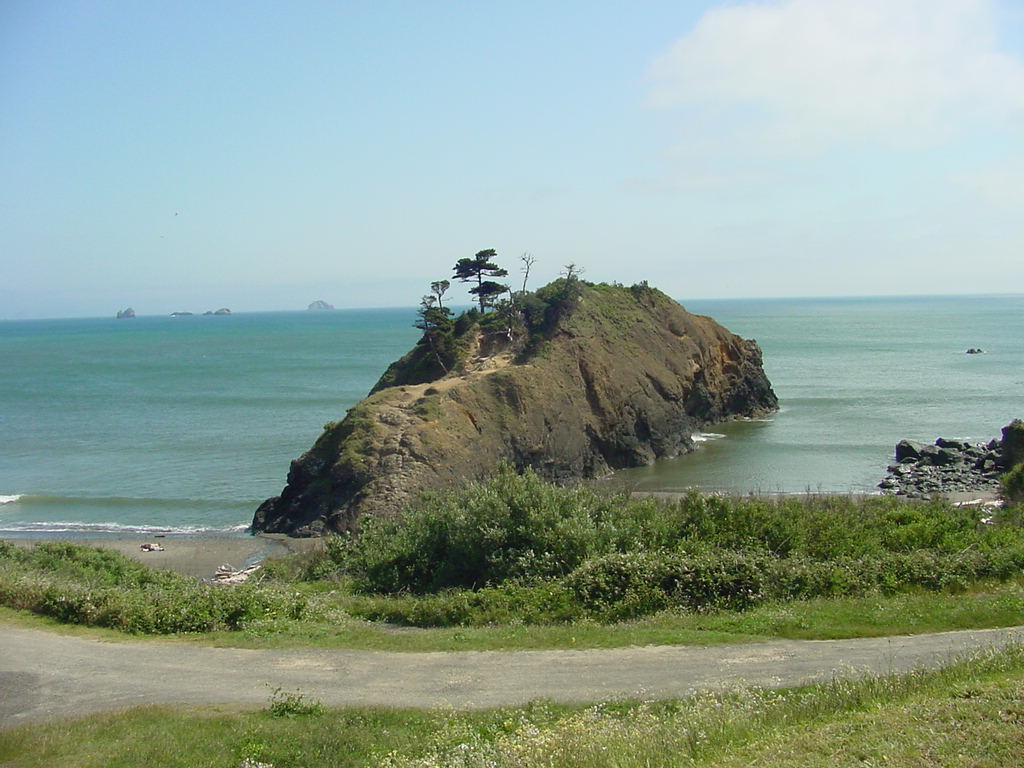

On this day, July 3, 2015, I found the Cyber State of Fremont, the first step in Fremont becoming the 51st. State.
The Republican Party is disintegrating as I predicted. Seven years ago I became a Republican so that my family history could help in the reconstruction of the Grand Party founded by my kindred, John Fremont, who married Jessie Benton, whose father Senator Thomas Hart Benton, was the proprietor of the Oregon Territory. Fremont played a big role in Oregon and California becoming a State. Fremont means ‘Guardian of Liberty’.
What I propose, is the leaders of the State of Jefferson adopt the ideals of John Fremont and the early Republicans, even change the name of their proposed state, to Fremont. Because Jessie and Susan Benton held Salons in Paris and San Francisco, I see the new State of Fremont offering a sanctuary to serious Artists and Writers. I suggest a Creative Homesteading Act that will give land away to creative souls. Port Orford, can be a creative colony for artists and writers.
The Internet will always be free in the State of Fremont. We can build a new Internet without the flaws that allow the original Internet to be hacked. I am going to invite the founders of Wikipedia to make Fremont their home. Indeed, we invite all men and women who are inventors and innovators to become citizens of Cyber Fremont, for the time being, until we can become a State with borders and land.
I also propose the return of free antennae Television, and the city of Fremont California becoming a Sympathetic City. We will establish a Bohemian Colony in Puerto Rico.
For the reason a supporter of the State of Jefferson employs two crossed Confederate flags on his site, I am compelled to put forth this Declaration. John Fremont was the first Presidential candidate for the newly founded Abolitionist Republican Party. John Breckenridge was running as the rival Vice President. Breckenridge was a close kin of Jessie Benton. It is my dream to see the bitterness of the Civil War be put behind us in the State of Fremont, and our new focus on Freedom, be a lighthouse to the Nation and the World. Being good Guardians of Freedom should be our goal. Let our statue of ‘The Guardian of Liberty’ be erected on our shore!
Jon Presco
Copyright 2015
President: Royal Rosamond Press

The fact is, the 1941 move for statehood was mostly a publicity stunt. It was crafted over drinks by two guys who seem right out of central casting for a Hollywood movie — a high-rolling, back-slapping business promoter and a hard-drinking, wildly imaginative newspaper man.
The newsman actually won a Pulitzer prize for his part in the affair. His name was Stanton Delaplane; he wrote for the San Francisco Chronicle.
The business promoter was a stocky, dynamic man named Gilbert E. Gable, onetime dinosaur egg hunter, movie maker, NBC radio-show star and (he claimed) Navajo Indian chief. In 1941, he was mayor of the tiny Oregon town of Port Orford and, for a brief and shining moment, governor of the State of Jefferson.
The radio star
By the early 1930s, Gable had gotten involved in the new world of radio broadcasting with an NBC show called “Highway of Adventure” (sometimes listed as “High Road to Adventure”), in which he recounted spine-tingling moments from the previous dozen years of hunting for dinosaur eggs and exploring unknown landscapes. He also sought and won the hand of Miss Paulina Stearns, daughter of a wealthy Michigan timber family. And then, in 1933, he went to Port Orford — probably to search for the legendary Port Orford Meteorite. It was a historic moment indeed.
“Two years later, to the amazement of its 300 inhabitants, Gilbert Gable appeared at Port Orford, Ore., and formed six companies to promote it as the only natural deep-water harbor on the rugged coast between Puget Sound and the Golden Gate,” reports TIME Magazine in its somewhat supercilious 1938 article.

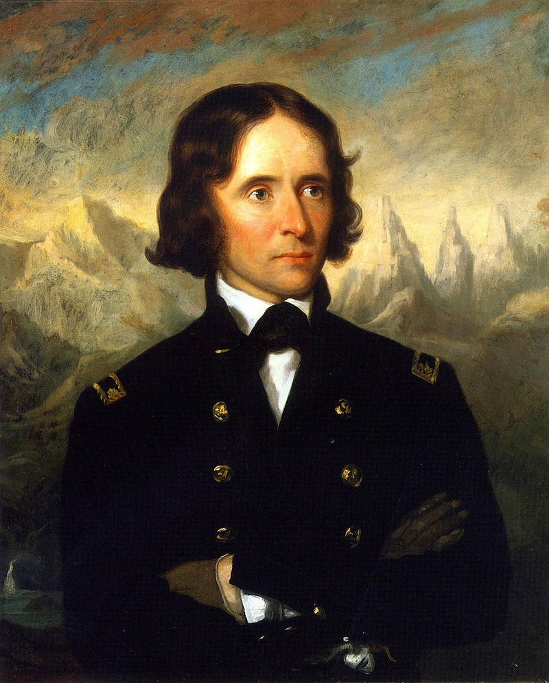


http://www.history.com/topics/us-states/california/videos/state-of-jefferson
http://www.huffingtonpost.com/2015/07/03/donald-trump-hispanic-leaders_n_7719582.html
http://www.huffingtonpost.com/2015/07/02/rick-perry-african-americans_n_7716760.html
A host of candidates were nominated for the Vice Presidency, but a number of them attempted to withdraw themselves from consideration, among them the eventual nominee, John C. Breckinridge of Kentucky. Breckinridge, besides having been selected as an elector, was also supporting Linn Boyd for the nomination. However, following a draft effort lead by the delegation from Vermont, Breckinridge was nominated on the second ballot.
Frémont first met frontiersman Kit Carson on a Missouri River steamboat in St. Louis during the summer of 1842. Frémont was preparing to lead his first expedition and was looking for a guide to take him to South Pass, in present-day Wyoming. South Pass, discovered by Jedediah Smith, was by that time the most popular way across the continental divide. Carson offered his services, as he had spent much time in the area. The five-month journey, made with 25 men, was a success. He wrote A Report on an Exploration of the Country Lying between the Missouri River and the Rocky Mountains on the Line of the Kansas and Great Platte Rivers, which was printed in newspapers across the country; the public embraced his vision of the west not as a place of danger but wide open and inviting lands to be settled.[17] As Hampton Sides says, “Fremont became an instant celebrity, a champion of expansion, a conqueror wielding not a sword but a compass and a transit.”[17] Henry Wadsworth Longfellow said after the report, “Fremont has touched my imagination. What a wild life, and what a fresh kind of existence! But ah, the discomforts!”[17] The success led to a new expedition planned for the next summer.
Second expedition[edit]
Frémont’s successful first expedition led quickly to a second, begun in the summer of 1843. The more ambitious goal this time was to map and describe the second half of the Oregon Trail, from South Pass to the Oregon Country. Due to Carson’s proven skills as a guide, Fremont invited him to join the second expedition. They followed a route north of the Great Salt Lake, down the Snake River to the Columbia River and into Oregon.
Farther west along the Columbia, they came within sight of the Cascade Range peaks and mapped Mount St. Helens and Mount Hood. Rather than continue west through the Columbia River gorge to Fort Vancouver, the party turned south and followed Fall Creek to its headwaters near the present-day northern border of California.
Looping back to the east to stay on the eastern side of the Sierra Nevada mountain range, they turned south again as far as present-day Minden, Nevada. From there, the expedition turned west into the Sierra Nevada, becoming some of the first Americans to see Lake Tahoe. Carson led the party to a new pass through the Sierra, which Frémont named Carson Pass in his honor. Once successfully over the high pass, the party descended the American River valley to Sutter’s Fort (Spanish: Nueva Helvetia) at present-day Sacramento, California.
Polls show millennials are likely to favor gay marriage regardless of their political party.
Sixty-one percent of Republicans between the ages of 18 and 34 back gay marriage, according to a Project Right Side and American Unity Fund poll last month. That’s 4 percentage points higher than the 57 percent support among all voters. The poll has a margin of error of plus or minus 2.19 percentage points.
Port Orford (Tolowa: tr’ee-ghi~’- ’an’ [5]) is a city in Curry County on the southern coast of Oregon, United States. The population was 1,133 at the 2010 census.
The city takes its name from George Vancouver‘s original name for nearby Cape Blanco, which he named for George, Earl of Orford, “a much-respected friend.”
Port Orford is the westernmost settlement in the state of Oregon.[6]
As of the census of 2010, there were 1,133 people, 603 households, and 285 families residing in the city. The population density was 726.3 inhabitants per square mile (280.4/km2). There were 767 housing units at an average density of 491.7 per square mile (189.8/km2). The racial makeup of the city was 93.3% White, 0.6% African American, 1.4% Native American, 0.5% Asian, 0.9% from other races, and 3.3% from two or more races. Hispanic or Latino of any race were 4.3% of the population.[2]
There were 603 households of which 11.8% had children under the age of 18 living with them, 35.3% were married couples living together, 8.8% had a female householder with no husband present, 3.2% had a male householder with no wife present, and 52.7% were non-families. 43.4% of all households were made up of individuals and 15.6% had someone living alone who was 65 years of age or older. The average household size was 1.86 and the average family size was 2.47.[2]
http://www.oregonlive.com/travel/index.ssf/2013/04/port_orford_an_artists_enclave.html
http://portorfordartscouncil.org/
On the issue of the Confederate flag, another hot-button topic on which public opinion has rapidly shifted following a massacre in a historically black church in Charleston, South Carolina, Perry again deferred to the states. When asked for his thoughts on whether South Carolina ought to take down a Confederate battle flag flying outside its state capitol, he said it was a question for the state’s residents. He quickly pivoted to discussing efforts to ban the flag from license plates in Texas while he was governor.
Tax Rebellion in the State of Franklin
The State of Jefferson is a proposed U.S. state that would span the contiguous, mostly rural area of southern Oregon and northern California, where several attempts to separate from Oregon and California, respectively, have taken place in order to gain statehood.
This region on the Pacific Coast is the most famous of several that have sought to adopt the name of Thomas Jefferson, the third President of the United States. Thomas Jefferson sent the Lewis and Clark expedition into the Pacific Northwest in 1803, and envisioned the establishment of an independent nation in the western portion of North America which he dubbed the “Republic of the Pacific”,[1] hence the association of his name
The State of Franklin (also the Free Republic of Franklin or the State of Frankland[note 1]) was an unrecognized, autonomous “territory” located in what is today eastern Tennessee. Franklin was created in 1784 from part of the territory west of the Appalachian Mountains that had been offered by North Carolina as a cession to Congress to help pay off debts related to the American War for Independence. It was founded with the intent of becoming the fourteenth state of the new United States.
Franklin’s first capital was Jonesborough. After the summer of 1785, the government of Franklin (which was by then based in Greeneville), ruled as a “parallel government” running alongside (but not harmoniously with) a re-established North Carolina bureaucracy. Franklin was never admitted into the union. The extra-legal state existed for only about four and a half years, ostensibly as a republic, after which North Carolina re-assumed full control of the area..
The Bohemian Alchemist Rose
Posted on February 13, 2024 by Royal Rosamond Press


I made a claim for all the Bohemian castles that were seized by the Nazis, and then by Russia, that along with the Traitor Trump, are using terror to get their victims to yield. For Trump to threaten to disarm NATO, and allow Putin to do what the hell he wants in regards to killing many people, I am asking the Czech Republic to install me in Český Krumlov castle, so I – the embodiment of Merlin – can conduct experiments, and make magic that will vanquish the…Enemies of the other Light!
Three days ago, a member of the Schwarzenberg family, sent me a letter – with photo of Merlin’s great granddaughter.
“Mr. Presco. We are so pleased to know the Sensheim lineage has not died out. We are working feverishly with the Czech government to put you in possession of Krumlov castle, that is being possessed by Vivian, who clains she descend from Merlin. If you do not come to Prague, we are going to send this Devil to you in Oregon.
The Rose of Bohemia
Posted on October 10, 2016 by Royal Rosamond Press


Belle inquires about my pen name, Ambrose, which I googled after she said her lover was named Ambrose. I discovered she has been arrested. There is a photo of her hands upon which someone has written a message, like a SPELL.
On Sunday, April 20, 2014 11:51 AM, Belle Burch wrote:
Yes, those are my hands in the RG. That was the first time I had ever appeared in the news as an activist.
Yes, I got a misdemeanor along with 11 other people for trying to talk to a silent and (cowardly) hiding John RUIZ.
I LOVE Crouching Tiger. It’s one of my favorites. The scene where the two young warrior lovers are in the bath together in the desert is my favorite part I think.
Is Bohemian a language as well as a place? Or are you referring to Romani? Was Romani the language that was spoken in Bohemia?
I’d like to hear more of your personal life story. “When I got sober”, “When I was homeless”, “When I was fighting cancer”……. these are words you drop and then let flit by without much detail or explanation or storytelling. I want those details and stories. Please.
Tell me what you thought of my poem. Did it make you feel anything? Did it make you think? If so, what?”
These are personal questions a woman seeking to be engaged would ask of her future husband. My love for Belle was sealed forever by her inquiry. If I was a man of thirty, we would be married – with two children! We would have founded a Bohemian Dynasty in America.
What I will present to you my reader, is the idea that I am the Dream of the Alchemist Rose, come true! The Rosenbergs were sponsors of great alchemists. I was a guinea pig for the LSD manufacturers, the alchemists of our age. Belle had taken LSD. She was very curious who I was. Why wasn’t she satisfied with all the information in this blog? Why did she want me to e-mail her very personal information? She wants to be seen as my close confidant. Why?
The only answer is, she wanted to steal my study! But, what part of her is the thief, and what part of her is the recipiant? Husbands and Wives exchange information, including Genetic Material. Because I died, and was reborn – we became husband and wife united and made one by a Higher Law! I have chased her through the Last Door, to take back – what is mine? How about………..what is ours?
I told Belle she was going to be my Heir before we met at The Wandering Goat. I recognized her the moment I lay eyes on her. I captured the moment she saw me. She knows me. My heart was pounding, as if I had been in a long race.
Jon Ambrose

http://alchemyguild.memberlodge.org/page-311919
The rose is the official flower of the Guild and fresh roses are present at all Guild meetings. The placement, color, and state of bloom of the roses carry subtle messages for Guild members on the nature of the meeting
http://alchemyguild.memberlodge.org/page-311915
Český Krumlov (Czech pronunciation: [ˈtʃɛskiː ˈkrumlof] ( listen); German: Krummau an der Moldau or Böhmisch Krummau; Krumau; English: Crumlaw,[1][2][unreliable source?] Bohemian Crumlaw, Crumlov or Chesky Crumlov ), translated sometimes to Czech Crumlaw, is a small city in the South Bohemian Region of the Czech Republic where Český Krumlov Castle is located. Old Český Krumlov is a UNESCO World Heritage Site[3] and was given this status along with the historic Prague castle district.
The city is named Český Krumlov (“Bohemian Crumlaw”) to differentiate it from Moravský Krumlov in South Moravia.
Schwarzenbergs
Roses were the favourite flowers of the alchemists. Several treatises are entitled The Rosary of the Philosophers. White roses were linked to the white stone, the objective of the first stage of the Word, while the red rose was associated with the red stone, the objective of the second stage. Red is cognate with gold. An old myth tells how Bacchus favoured Midas, whose touch turned things to gold, and that the king resided where there was a garden with roses having sixty petals and unsurpassed fragrance. The Popes used to bless a Golden Rose on the fourth Sunday in Lent, as a symbol of their spiritual and didactic power, of resurrection and immortality. Ironically the Golden Rose was twice conveyed to Henry VIII who broke with Rome. His dissolution of the monasteries significantly occasioned the transfer into private hands of the cloistered rose-gardens hitherto maintained by the religious houses. The Red King and the White Queen figure frequently in alchemystical allegory. Their successful union is acknowledged by use of the rose symbol. One alchemical figure shows a vessel that is penetrated by a rigid object and from which rose blooms show forth. The alchemical treatises obviously contain great mysteries for those who have the acumen to rend the many veils that are drawn by the alchemical philosophers over what are the axiomatic truths of generation and rebirth.
http://www.whitedragon.org.uk/articles/rose.htm
The Schwarzenbergs belonged among the most significant noble families in the Czech lands. In 1660, they gained the first Czech dominion – Toeboo. Originally, however, it was a German family of the Lords of Seinsheim which came from Lower Franconia
http://www.ckrumlov.info/docs/en/mesto_histor_alchym.xml
Alchemy in Český Krumlov
The second half of the 16th century is usually called “the golden age of alchemy”. Beside EmperorRudolf II. von Habsburg, it was Wilhelm von Rosenberg who became the most important Maecenas of the hermetic sciences, especially of alchemy. Around the House of Rosenberg, in fact, arose a second center of hermetic and alchemic activity. Not only renowned and lesser known enthusiastic seekers, but also skilled con artists worked their magic in the Prague Rosenberg Palace as well as in different seats of Wilhelm’s South Bohemian dominion – in Třeboň, Prachatice, and especially in Český Krumlov, which used to be called “the South Bohemian Mecca of alchemists”
History of the town of Český Krumlov
According to legend, the name Krumlov is derived from the German “Krumme Aue”, which may be translated as “crooked meadow”. The name comes from the natural topography of the town, specifically from the tightly crooked meander of the Vltava river. The word “Český” simply means Czech, or Bohemian (actually one and the same), as opposed to Moravian or Silesian. In Latin documents it was called Crumlovia or Crumlovium. The town was first mentioned in documents from 1253, where Krumlov was called Chrumbonowe.

The flow of the Vltava River has long been a natural transportation entrance to this region. The area\’s oldest settlement goes back to the Older Stone Age (70,000 – 50,000 B.C.). Mass settlement was noted in the Bronze Age (1,500 B.C.), Celtic settlements in the Younger Iron Age (approx. 400 B.C.) and Slavonic settlement has been dated as from the 6th century A.D. The Slavs were represented by two tribes – Boletice and Doudleby. (Prehistorical settlements of the Český Krumlov region )
 In the Early Middle Ages the routes along the Vltava river created the trade routes (see Historical Routes in the Český Krumlov Region). In the 9th century the area was probably owned by the noble Czech family of Slavníkovci, who were slaughtered by the rival family of Přemyslovci in 995. This area then became their property. In accordance with the principles of internal colonization and bestowing of sovereign domains in fief to members of a sovereign dynasty, this domain was thus given by the ruling family of Přemyslovci to one of their own lines – The Witigonen in Czech known as the Vítkovci.
According to the legend, the family of Witigonen has its origins in Ancient Rome. The family was related to the Roman Ursini family, who is said to have resided on the mountain “Mons Rosarum” near the city of Rome. After Rome was plundered by the hordes of the Visigoth leader Totila in 546, the family left Rome and one of its members named Vítek (in German, Witigon) travelled together with his wife and child up to the north, passed the Donau river and settled in Southern Bohemia. He started a new family there and gradually acquired extensive domains, which he gave to his five sons before his death. Each son received a coat-of-arms with a five-petalled rose, the color of which symbolized each particular dominion.
So much for legend – historical reality offers us some slight variations. Vítek did not come to South Bohemia in the 6th but the 12th century, and he did not come from the Italian family of Ursini but from the family line of a Czech Princess of the Přemyslovci. In 1173Vítek of Prčice was mentioned as an envoy to the Emperor Friedrich Barbarossa, and in 1179 he apparently settled in Southern Bohemia. The fact that his domains were not liable to the so-called law of escheat indicates his strong influence, as his property did not have to return to the hands of the family of Přemysl. Vítek could freely dispose of his properties and therefore gave it to his four sons – Jindřich of Hradec; Vítek II senior, predecessor of the Lords of Krumlov; Vítek III junior, founder of the family of Rosenberg; and Vítek IV. It is likely that the then newly founded residences Nové Hrady (New Castles), Rožmberk (Rosenberg), Třeboň and Krumlov fell into the rank of domains of the Vítek family, while Krumlov would have been their fourth castle in the rank. This historically important moment is rendered in the painting “Division of the Roses“, which can be viewed in the sightseeing tour at the Český Krumlov castle.

In 1251 the Bohemian King Přemysl Otakar II gained Austrian lands through marriage to Anna Maria of Bamberg. Přemysl Otakar II, with his well-thought out colonization policy, tried to populate the sporadically settled Šumava region in the Czech-Austrian borderland and this way integrate his domains in Bohemia with his newly gained territories in Austria. His efforts in this sphere, however, had its consequences in territories ruled by the sovereign family of Vítkovci, which resulted in particular centres of conflicts with the most powerful aristocratic family in the country. Conflicts had their origins for example in the foundation of the royal town České Budějovice or the Cistercian Monastery Zlatá Koruna (Golden crown), both founded by King Přemysl Otakar II in 1263. Zlatá Koruna was supposed to restrain the influence of the Rosenberg monastery in Vyšší Brod, founded by Peter Wok von Rosenberg in 1259. Frequent disagreements and armed clashes between Přemysl Otakar II and members of the particular branches of the Vítkovec family eventually weakened the power of the Bohemian King.
According to his master, the renowned engineer of the pond and lake system in South Bohemia and Rosenberg regent Jakub Krčín of Jelčany devoted himself to alchemy. But his interest in alchemy was simply for pleasure, not profit. He set up a laboratory at Nový hrádek in Křepenice near Sedlčany.

On the recommendation of Václav Vřesovec of Vřesovice (1532 – 1583), a Prague supporter of alchemy, the renowned Italian alchemist Claudius Syrrus came into Wilhelm’s employ as well. We have a preserved text of the work contract between the alchemist and the Rosenberg sovereign as recorded by the chronicler Václav Březan. In the contract listing seven conditions, it is written that the alchemist reserves the right to be spiritually and physically free and independent, and makes it a condition not to be disturbed by anybody, with the personal exception of Wilhelm von Rosenberg. Should the occasion arise that the philosophical stone is actually produced, it is arranged that Claudius Syrrus receives a half share of it. In addition, a note was anchored in the contract saying that a purely positive result was not guaranteed.

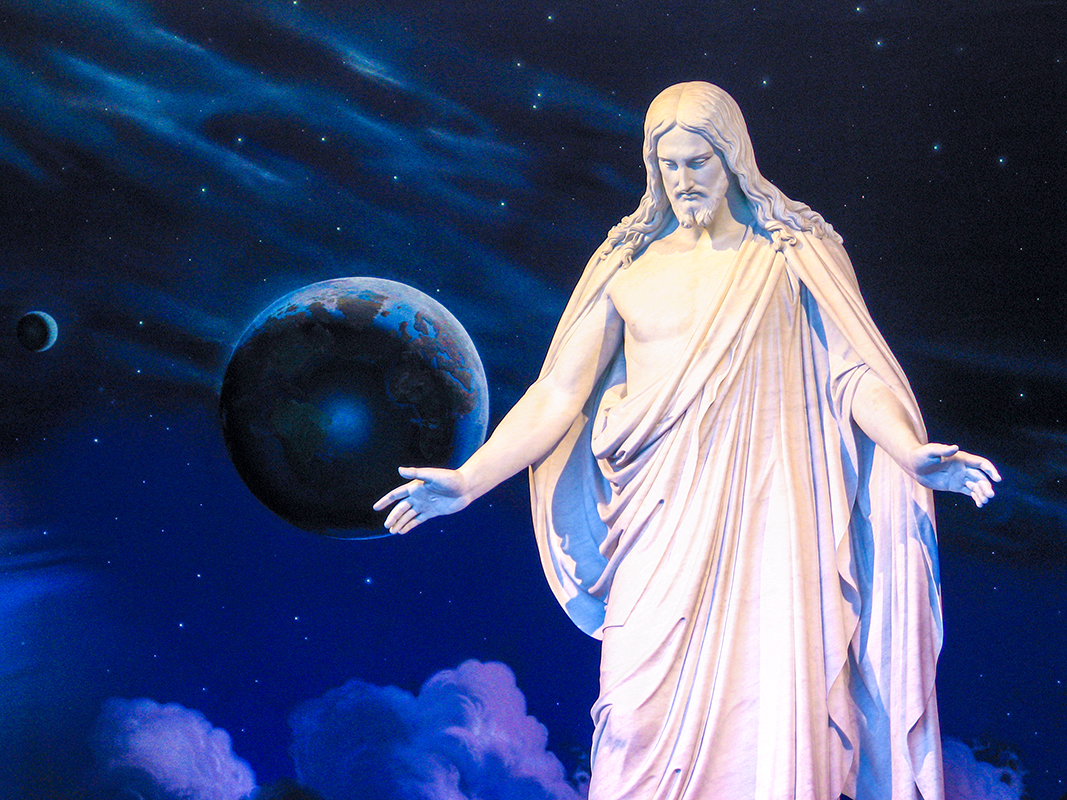
Leave a comment