After reading the home of Captain Cogswell was near where Temescal Creek flows into the Bay, I went in search of it, and read it surfaced on Thornhill, where Michael Harkins lived, and near Miles, where I lived with my wife, Mary Ann. I recall on Earth day my step-daughter and I went to clean up our creek that flowed near the DMV where stood the largest canary in the world. WTF?
Waterfront Johnny
Temescal Creek


Temescal Creek in Fernwood
CC SA-BY Our Oakland
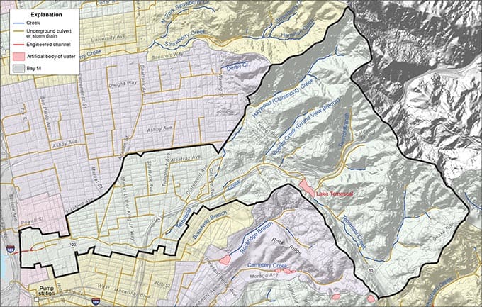
Temescal Creek is a major Oakland stream that drains the stretch of the north Oakland Hills between the watersheds of Strawberry Creek and Sausal Creek and debouches into San Francisco Bay in Emeryville. Its valley was dammed by Anthony Chabot in 1868 to form Oakland’s first municipal-scale water supply, the water body now known as Lake Temescal.
The creek originates as spring-fed streams in the canyon leading to the Caldecott Tunnel and the hills above Thornhill Road in Montclair. Its main stream, formerly called Kohler Creek, runs openly through Fernwood to Lake Temescal, where it is joined by the Tunnel Branch. Its reach below the reservoir is almost entirely culverted. Farther downstream it is joined by Vicente Creek and Claremont (formerly called Harwood) Creek. It is briefly exposed east of Golden Gate Drive and in a few properties along Chabot Road, most notably St. Albert the Great Priory. The stretch of occasional running water in Oakland’s Temescal Creek Park, parallel to Claremont Avenue between Clifton and Clarke Streets, is an artificial water feature; the culverted stream lies some 15 feet below. The culverted stream is also honored by interpretive monuments in the Logan residential building at 51st Street and Telegraph Avenue, at 4921 Shattuck Avenue by the post office building, and in Emeryville’s Temescal Creek Park on 47th Street.
The creek was the principal stream in Jose Vicente Peralta‘s rancho, and his home was situated by the creek. The site was once an Ohlone village whose temescal sweat lodges were noted by early visitors in often lurid passages. The area along the creek above 51st Street was once known as Humboldt Park, with a garden and rifle shooting gallery.
Temescal Creek (Temescal, Mexican Spanish for “sweat lodge“) is one of the principal watercourses in the city of Oakland, California, United States.
The word “temescal” is derived from temescalli/temazcalli (variously transliterated), which means “sweat house” in the Nahuatl language of Mexico. The name was given to the creek when it became part of the Peralta’s Rancho San Antonio. It is surmised that the Peraltas or perhaps one of their ranch hands (vaqueros) had seen local indigenous (Ohlone) structures along the creek similar to those in other parts of New Spain which were called temescalli or “temazcalli”.
Three forks begin in the Berkeley Hills in the northeastern section of Oakland (also referred to as the Oakland hills south of the Caldecott Tunnel), part of the Pacific Coast Ranges, coming together in the Temescal district of Oakland, then flowing westerly across Oakland and Emeryville to San Francisco Bay.
The north fork of Temescal Creek was renamed “Harwood’s Creek” in the mid 19th century after an early claimant to grazing lands in the canyon above the Claremont neighborhood, retired sea captain and Oakland wharfinger William Harwood. It was renamed yet again “Claremont Creek” in the early 20th century after a residential development in the same vicinity, today’s Claremont district.
The middle fork flows through Temescal Canyon mostly in underground culverts, beneath the Grove Shafter Freeway starting near the Caldecott Tunnel and underneath the interchange with State Route 13. It joins the south fork at Lake Temescal.[3] Before the Caldecott tunnel project (1934–37), this fork entered the lake via a prominent inlet that was traversed by a trestle bridge of the Sacramento Northern Railroad. The inlet was filled in and the trestle replaced by a large concrete embankment which exists to this day.
The south fork begins in the northern section of Oakland’s Montclair district, flowing southwest out of a canyon in the hills alongside Thornhill Road, then turning abruptly northwestward in the linear valley formed by the Hayward Fault. It then flows into Lake Temescal, a natural sag pond which was dammed in the 19th century to increase its capacity for use as a reservoir. Lake Temescal is now a public park.
The creek continues out of the northernmost corner of Lake Temescal into another underground culvert. The tunnel follows the Grove Shafter Freeway and briefly re-emerges next to Saint Albert’s Priory next to Presley Way and Miles Avenue. It continues westerly around the end of the shutter ridge in the Rockridge district of Oakland, where it joins the north fork (Claremont Creek) at approximately the intersection of Forrest Street and Miles Avenue.
A small section of above-ground creek exists as the Rockridge-Temescal Greenbelt parallel to Claremont Avenue between the Grove Shafter Freeway and Telegraph Avenue. A pumping station at the top of the greenbelt diverts water from the tunnel and pumps it up to the surface creek.[4] After Telegraph Avenue the tunnel continues east underneath the Temescal Community Garden and Temescal Creek Parks, then follows 53rd Street through Emeryville to its mouth at Bay Street.[3]
Mouth area[edit]
| External Map | |
|---|---|

Temescal Creek is a perennial stream, and as such, was highly valued by early settlers. At its mouth, the indigenous Ohlone people (Chochen/Huichin band), and their predecessors, built up the shellmound of Emeryville, the largest and most studied shellmound on the shoreline of San Francisco Bay.
When the area was part of the Peralta’s Rancho San Antonio, the site near the shellmound was one of the landings for the ranch where their cattle and hides were loaded for shipping.[5] Cattle and other livestock were slaughtered in this vicinity right up through the early 20th century for various meatpacking plants in an area which became known as “Butchertown”.[6]
It is believed that Temescal Creek once supported a population of rainbow trout, though urbanization and the damming at Lake Temescal have led to their decline.[7] Archeological evidence indicates that coho salmon were also likely found at one time in the creek.[8] The Emeryville Shellmound is also notable for its remains of beaver (Castor canadensis).[9]
Today, the creek is mostly underground in culverts in the flatlands, but many stretches are open above Lake Temescal. In 2000, a segment of the creek below the tracks of the Union Pacific Railroad in Emeryville became accessible to the public after the demolition of one of the buildings of the historic Sherwin-Williams paint factory in early 2000. Temescal Creek now flows in an open culvert through the 2002 Bay Street Mall development. This is just about the spot where the Emeryville Shellmound once stood. A small informational park commemorating the creek and the Ohlone presence at the site is situated here.
At Shellmound Street, which runs approximately along the original Bay shoreline, the creek returns to a culvert which takes it to San Francisco Bay. This straight course, however, is a later imposition – the original course of the creek bent south and entered the Bay near the northern edge of the IKEA property. Temescal Creek near the mouth area is channelized with concrete linings. The mouth of Temescal Creek at the discharge to San Francisco Bay is fully tidal and consists of mudflats and marshland. Historically both banks of Temescal Creek in the lower area of Emeryville were part of the San Francisco Bay tidal floodplain and were extensively filled from about 1900 through the 1970s. Fill included slag, soil and other inert materials originating from the Judson Steel plant.[10] The Judson plant occupied much of the lower reach banks in Emeryville; Judson used this reach for metal recycling/recovery. Foundations remained of a shear, tin baler, scale, and conveyor as late as 1990 when the lower banks were renamed the “Chiron” site and re-developed.
The 6.7-square-mile Temescal Creek Watershed spans the northernmost section of the Oakland hills and includes several regionally significant parks managed by the East Bay Regional Park District (EBRPD). South of Highway 24, two of the watershed’s four creeks drain the Montclair residential district and flow into Lake Temescal. North of the highway, the other two creeks drain the Claremont hills residential area and Claremont Canyon Regional Preserve. Both of these join the main channel of Temescal Creek below Lake Temescal, from which point water flows primarily through culverts to the Emeryville Crescent State Marine Preserve. Here, visitors can enjoy spectacular views of both the Golden Gate and Bay bridges.
Download .KMZ map (Requires Google Earth)
History
Small tribelets of Ohlone thrived in the native annual grasslands along with abundant grizzlies, tule elks, and millions of shorebirds, moving up and down the creek with the seasons from 2,500+ years ago until Spanish colonization beginning mid-1700s. More recently with much of the creek buried by a concrete jungle, humans have lost a real sense of Temescal Creek watershed of today. While much of it is now underground, on any given day you might see rainbow trout, river otters, and dragonflies meandering about in segments that remain open. In other parts of town, you can celebrate the rich history that lies beneath the streets through reconstructed creek sections, art pieces and memorials found along its path. Most importantly, you can reconnect with the flora and fauna that have been living around you all along. They are your neighbors, your watershed neighbors, all sharing the Temescal Creek Waterhood.
The Huichan Ohlone were the first people to settle the banks of Temescal Creek. They lived in tule reed houses built alongside the creek and on top of shellmounds. A willow thicket at the mouth of the creek and adjacent mudflats provided a rich ecosystem suitable for hunting, fishing, and gathering. Tule reeds provided material for boats, houses and sweathouses. The Huichan gathered oysters, shrimp and clams from the marshes, hunted elk, deer and small mammals among native annual grasses, fished for steelhead and salmon in the creek, feasted on beached whales and harvested acorns in the hills.
The Huichan Ohlone lived in small independent tribelets along Temescal Creek until the late mid-1700’s when Spanish explorers and missionaries arrived in the SF Bay Area. Missionaries and soldiers brought the Ohlone into the missions and forts they established around the Bay while European diseases, and European/native skirmishes decimated native populations. Within 100 years, nearly all of the 17,000 Ohlone and Miwok peoples that had lived in the Bay Area were gone and the land carved into rancherias divided between original Spanish/Mexican settlers to the area.

Ohlone in a Tule Boat on San Francisco Bay, 1816 by Louis Choris
In 1820, the Spanish government was granted to the Peralta family granted 44,000 acres of land, including the 6.7 square-mile stretch of the Temescal Creek watershed. The Peralta’s wealth and influence formed Rancho San Antonio into the social and commercial center of the area. The cattle they brought in replaced the tule elk, prong horned deer and destroyed the native grasslands, compacting the soil and forever altering the shoreline ecology. Soon after, gold was discovered, and the subsequent arrival of tens of thousands of European and African American prospectors led to the rapid destruction of habitat, radical reduction in species numbers and varieties – the now extinct California grizzlies were killed by the thousands for sport, along with overhunting of elk, deer, whales, beaver, trout, salmon and many other species that were once found as a matter of course throughout the watershed.

by Amy Hosa & Linda Yamane, 2019.
The proliferation of non-Natives caused rapid urbanization.As a result, the creek was altered in a variety of ways. In 1868, the creek was dammed directly over the Hayward Fault to create Lake Temescal, a source of drinking water for the burgeoning city of Oakland. The fast rising population made this water supply obsolete within a few years and Lake Chabot came on line, both being built with Chinese labor by Anthony Chabot using hydraulic mining equipment and wild horses. Wealthy white artists, writers camped by the edges of the Lake. As neighborhoods grew around Temescal Creek (and other waterbodies), so did paved roads, highways, cement sidewalks and stormwater, With the creek no longer a vital source of water, it became trapped from naturally moving its course from side to side due to development along the creek. became less connected to their watershed. Buildings were increasingly built in proximity to the creek. By the mid 20th century, Temescal Creek was considered by many to be “a nuisance” filled with trash and sewage which overcame its banks with flood waters, This led most of the creek, below Lake Temescal being funneled into culverts and buried.
Today, Temescal Creek still begins and ends its journey in the daylight, while most of the creek is hidden underground. Over the past 200 years, many advocates have brought awareness around the value that a healthy creek system can bring to the community. Visit the Rockridge-Temescal Greenbelt and see the underground path it takes. Or visit Garber Park to see ongoing restoration efforts of the creek’s banks.

Leave a comment