Small cheap weather drones can be flown and parked at the edge of rivers . If they end up in a torrent of water they send a signal to a large relay unit that sounds sirens and activates phones. A personal drone might be available.
John
Move the 3D Model Around To Get a 360° View of the Meteodrone
A New Era of Precision in Meteorology
All over the world, severe weather conditions such as thunderstorms, strong winds, fog, and hail significantly impact the economy and public safety. To date, weather models have been limited by a lack of sufficient observations from the atmospheric boundary layer, hindering accurate predictions of these local weather phenomena. Weather drones present a solution to bridge this data gap.
The specially developed and patented Meteodrones offer an innovative method to gather weather data from both the lower and middle atmosphere. Equipped to capture high-resolution, direct measurements of critical meteorological elements such as temperature, humidity, air pressure, and wind speed, Meteodrones mark a significant leap forward in meteorological science. Incorporating these measurements into weather model calculations can demonstrably improve weather forecasts.
Talk to an expertSee our Meteodrone model
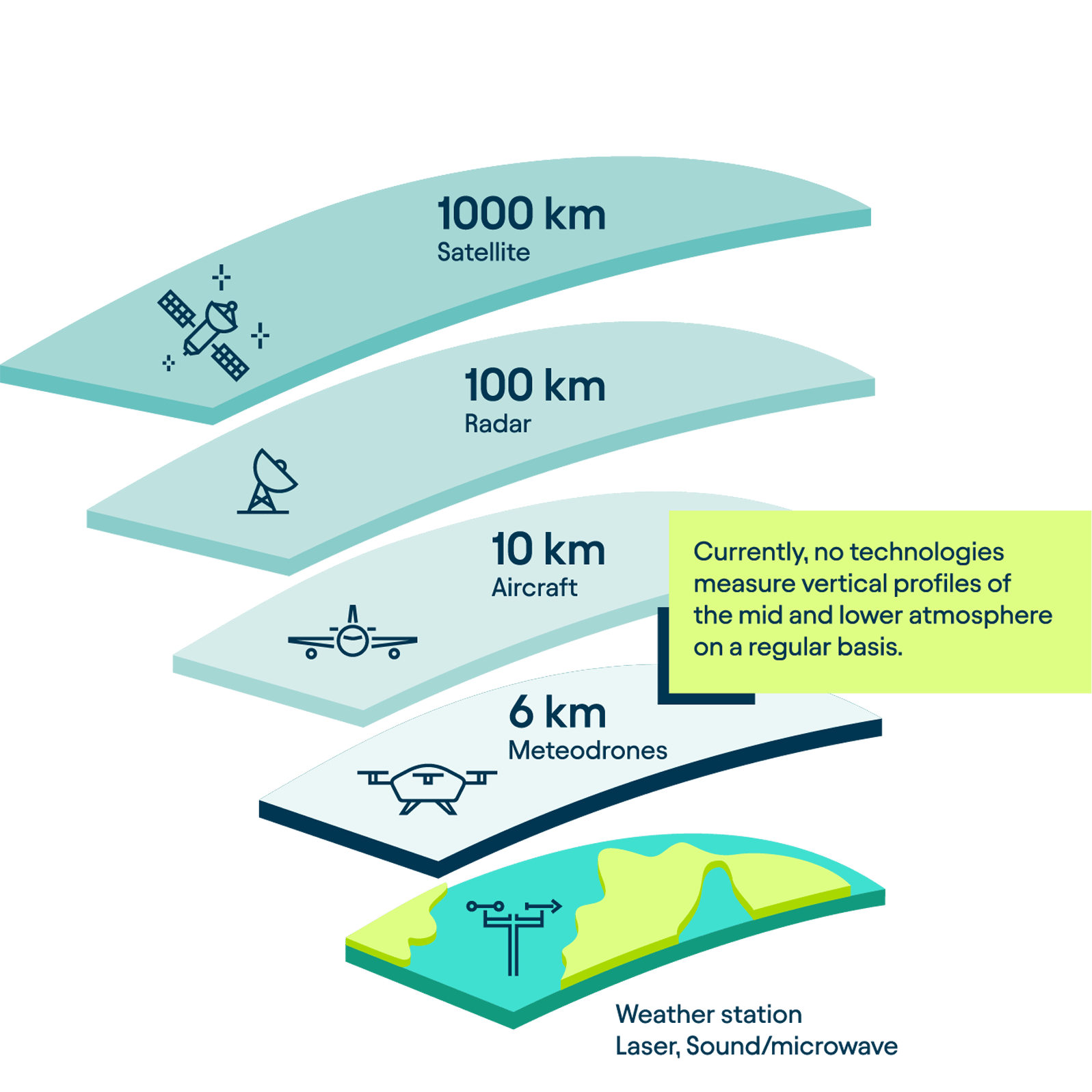
Challenges of Weather Data Collection
The boundary layer, the lowest layer of the atmosphere, is where the majority of our weather occurs. Everyday weather conditions are influenced by a multitude of variables and factors that are difficult to capture. Consequently, the data currently fed into weather models often lacks the comprehensiveness needed for precise weather predictions.
Weather Stations
Traditionally, weather data has been collected using weather balloons and ground-based weather stations. However, these stations, with their fixed locations and proximity to the Earth’s surface, have significant limitations in capturing atmospheric measurements. Being grounded, they are unable to assess conditions in the higher regions of the boundary layer.
Satellites
Satellites represent another method for collecting weather data. They are particularly effective in gathering information on water vapor and cloud formation. However, satellites are less suitable for measuring parameters like temperature, humidity, or wind. Additionally, satellite data is often collected intermittently and may lack the necessary quality and resolution for integration into weather models. While weather satellites are instrumental in collecting atmospheric observations and have significantly enhanced weather forecasting, they fall short in accurately profiling wind fields in the colder, lower atmosphere.
These data are crucial for industrial applications and for initializing weather models. Moreover, the presence of clouds can obstruct satellites from capturing measurements beneath them. Consequently, satellites offer limited coverage of the planetary boundary layer, leading to gaps in observational data.
Aircraft
Aircraft are another means of collecting weather data, frequently deployed during storm events. However, their operation entails significant costs. Additionally, piloting an aircraft into a storm poses considerable risk to human life.
Weather Balloons and Radiosondes
Weather balloons carrying radiosondes can ascend to much higher altitudes. However, they come with their own set of drawbacks. Lacking controlled navigation, they are at the mercy of wind currents and cannot return to their launch points. This often leads to coverage of unintended areas, making it challenging to collect consistent and targeted weather data in the form of a vertical profile or through vertical atmospheric surveys.
Moreover, the production of these radiosondes can be costly. They also require helium for operation, a natural resource that is becoming increasingly scarce. Post-deployment, radiosondes frequently drift as far as 250 km from their launch sites due to wind patterns, which often leads to the loss of the equipment.
Replace radiosondes with Meteodrones
Meteodrones: a Game Changer
What Are Weather Drones?
Weather drones are specifically engineered for meteorological purposes. Operating within the Earth’s lowest atmospheric layer, known as the boundary layer, they are equipped with sensors for weather data collection, gathering key atmospheric data such as temperature, humidity, and wind conditions. The information collected by these drones is instrumental in enhancing the accuracy of weather forecast models, providing a more comprehensive understanding of atmospheric dynamics.
What Makes Meteodrones So Special?
Made in Switzerland
Meteodrones are a product of Swiss precision and innovation. Entirely designed and engineered in St. Gallen, Switzerland, the development process of Meteodrones is an in-house endeavor from conception to final product.
Mobile weather station
We call our Meteodrones “the future of radiosondes.” Each Meteodrone functions like a mobile weather station, offering numerous benefits over conventional radiosondes. Unlike these probes, which often take measurements in an uncontrolled manner due to their flight paths, our Meteodrones are capable of precise, controlled operations. They can be manually directed on-site or operated remotely, providing flexibility in data collection. This allows the Meteodrones to hover over a specific location or venture into remote areas where traditional weather stations are absent and other forms of measurement are unfeasible.
Cost-Effective and Sustainable
Meteodrones serve as a more sustainable and cost-effective method of collecting atmospheric data compared to radiosondes, as they can be deployed and reused as often as needed. Additionally, their robust construction enables operation in a variety of weather conditions, making them highly effective in capturing a wide range of local weather phenomena. This reusability and versatility underscore Meteodrones’ role in promoting environmentally responsible meteorological practices.

Leave a comment